
The project
A catchment-to-sea approach to flood resilience.
EcoC2S co-develops a holistic approach to flood risk, quantifying how natural ecosystems and blue-green infrastructure can help reduce flood impacts in transitional and coastal areas — while working with the communities who live there to explore pathways towards greater resilience.

The challenge
Understanding compound flooding.
Coastal floods are among the most common natural hazards in Europe. Many of the most damaging are compound: heavy rain, a river in flood, a high tide, a storm surge and waves arrive at the same time, and their effects amplify each other.
Climate change is raising mean sea level and shifting the size and timing of river floods. At the same time, coastal wetlands may not be able to keep pace with rising sea levels. Yet coastal flood risk is still assessed mostly one driver at a time.
All along the water continuum, upstream wetlands, tidal marshes and beach dunes slow water down. But river and coastal flood regulation have so far been studied in isolation, and the people who benefit from these ecosystems often live far from them.
- 2020Storm GloriaSpanish Mediterranean coast
- 2021Central European floodsGermany, Belgium and neighbours
- 2022 & 2023Misa River floodsMarche, Italy
- Feb 2026Guadalete marshesBay of Cádiz, Spain
From gaps to novelties
Objectives
What we set out to do.
The co-development of a holistic flood risk assessment approach to quantify the contribution of natural systems and blue-green infrastructure to flood protection in transitional and coastal areas, and the co-creation and implementation of resilient pathways based on ecosystem services.
- O1
Reliable and affordable flood risk assessment that jointly considers geophysical and societal pre-conditions and all relevant flood drivers, with their dependencies and interactions.
- O2
Estimating the contribution of meteorological, eco-morphodynamic and human drivers to flood impact.
- O3
Valuing the water-flow regulation provided by inland and coastal ecosystems along the water continuum.
- O4
Assessing how ecosystems and blue-green infrastructure perform under climate change, including the resilience and geomorphic adaptation of coastal ecosystems to sea-level rise.
- O5
Assessing the socio-cultural and socio-economic value of ecosystem services for local communities, what determines it, and whether perceived changes predict the (non)acceptance of nature-based solutions.
- O6
Engaging local communities and stakeholders in co-identifying research needs and co-designing and co-implementing solutions, with a focus on overcoming barriers.
- O7
Promoting resilience pathways under climate change that are based on ecosystem services and are multifunctional, flexible, gender-responsive and adaptive.
Research questions
- How will sea-level rise and changes in extreme weather affect flood risk, considering compound flooding?
- How will these changes affect the ability of ecosystems to regulate water flows?
- How valuable to society are the ecosystem services that protect coastal regions?
- How can inland and coastal processes be integrated to understand change in ecosystem services?
- Which strategies should be prioritised in the transition to greater resilience to compound flood risk?
Conceptual framework
Five levels, one framework.
Stakeholders take part at every level: they help define the gaps, value the ecosystems and shape the scenarios and pathways.
- Level 1
Co-identifying knowledge gaps and valuing ecosystem services
With stakeholders: past events, perceived risks, protection behaviours and the biophysical, economic and socio-cultural value of ecosystems.
- Level 2
Characterising how flood drivers behave together
Rainfall, river discharge, storm surge, waves, tide and mean sea level — with joint-probability methods, reanalysis and regional climate projections.
- Level 3
An integrated, eco-morphodynamic modelling framework
From catchment (HEC-RAS) to estuary and coast (Delft3D), including vegetation, sediments and long-term marsh evolution, validated with field data and remote sensing.
- Level 4
Co-creating plausible futures
Scenarios for sustainable and resilient ecosystem services built with the IPBES Nature Futures Framework and climate scenarios SSP2-4.5, SSP3-7.0 and SSP5-8.5.
- Level 5
Resilience pathways
A framework of adaptive pathways to guide long-term mitigation and management, instead of a single deterministic plan.

Model
One framework for river discharge, tides, surges and waves — and how marshes and sediments respond.
Value
What wetlands, marshes and dunes actually contribute to flood protection, in physical, economic and social terms.
Co-create
Resilience pathways built with the communities and institutions who live with the risk.
Work packages
Six work packages, one table.
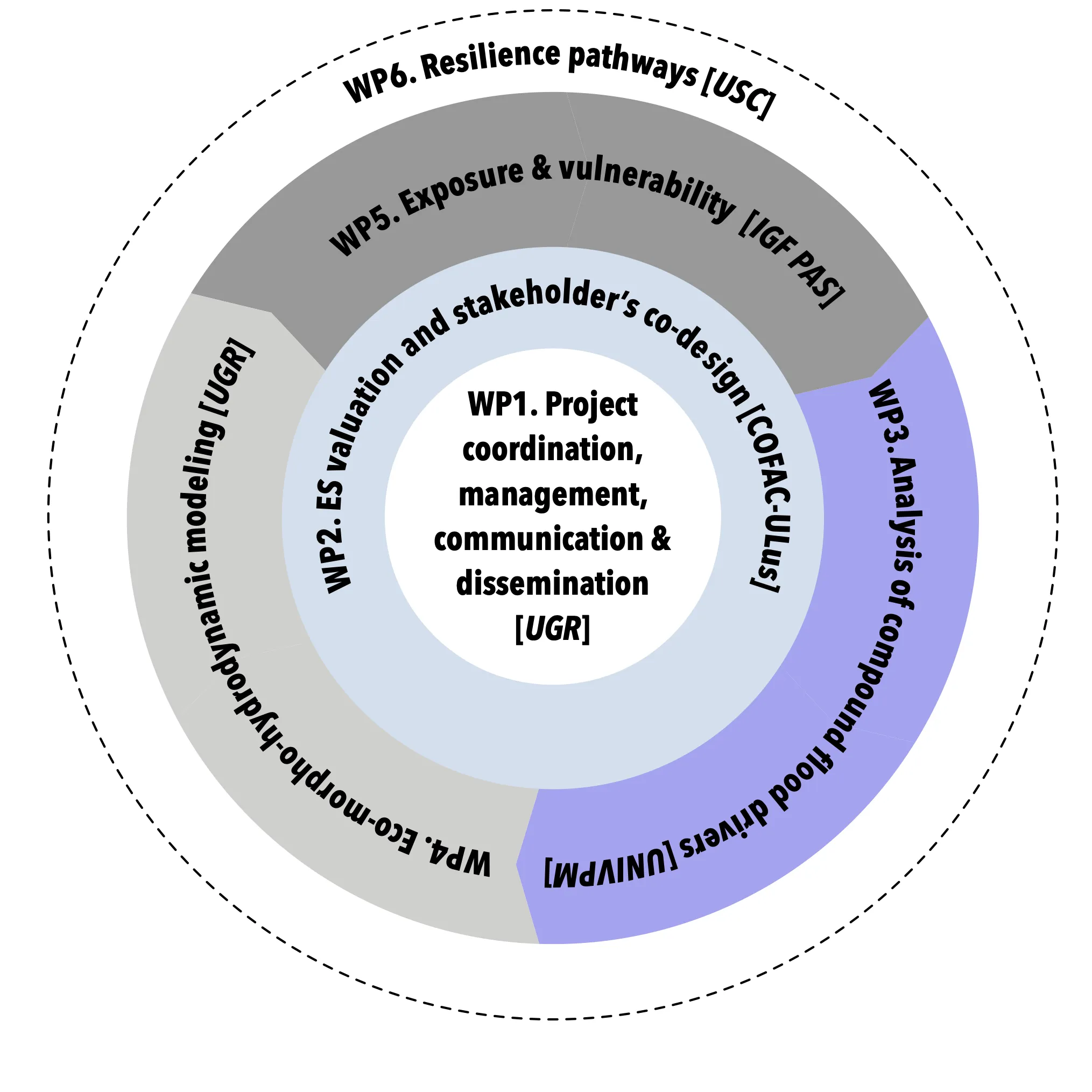
Coordinated by the University of Granada. Each partner leads the work closest to its expertise; KIT contributes to WP3, WP4 and WP5.
- WP1Led by UGR · María Bermúdez
Project coordination, management, communication & dissemination
Coordinates the consortium, ensures scientific quality and the participation of end users, and communicates and disseminates the project's results.
- Project coordination
- Scientific coordination
- Quality assurance and risk management
- Innovation
- communication and dissemination
Key outputs: Project website and joint publications · Final open hybrid workshop
UGRUNIVPMCOFAC-ULusIGF PASUSCKIT
- WP2Led by COFAC-ULus · Rui Gaspar
Ecosystem services valuation, social dynamics & stakeholders' co-design
Analyses how communities value the flow-regulation services of ecosystems, engages them in co-designing solutions, and builds Communities of Practice.
- Stakeholder network management
- Co-identification of research gaps and needs
- Ecosystem services valuation
- Co-design of solutions and strategies for resilience
Key outputs: Gaps identification report · Co-created strategies for resilient flood management · Training and Community of Practice guidelines
COFAC-ULusUGRUNIVPMUSC
- WP3Led by UNIVPM · Maurizio Brocchini
Analysis of compound flood drivers
Characterises how river discharge, rainfall, tides, storm surges and waves combine to cause floods, today and under climate change, and gathers the data in an open, searchable database.
- Meteorological
- hydrological
- morphological and oceanographic data
- Drivers under climate change scenarios
- Integrated database
Key outputs: Datahub with multidimensional data on all components of the flood hazard
UNIVPMUGRKITIGF PAS
- WP4Led by UGR · María Bermúdez
Eco-morpho-hydrodynamic modelling
Builds an integrated catchment-to-sea modelling framework that reproduces compound flooding and how marshes, vegetation and sediments regulate it — from single events to decades.
- Catchment-to-sea modelling framework (HEC-RAS + Delft3D)
- Formulations for biogeomorphic modelling
- Long-term eco-morphological modelling (SLAMM)
- Model validation
Key outputs: Flood hazard assessment of the two case studies
UGRKITUNIVPMIGF PAS
- WP5Led by IGF PAS · Michael Nones
Exposure & vulnerability
Characterises the exposure and vulnerability of people, assets and ecosystems with socio-economic indicators and remote sensing of coastal and intertidal habitats.
- Indicators of the social system
- General vulnerability indicators
- Ecosystem vulnerability from remote sensing
Key outputs: Report on exposure and vulnerability indicators
IGF PASKIT
- WP6Led by USC · Sebastián Villasante
Resilience pathways
Assesses the resilience of flood-regulating ecosystem services and co-creates plausible future scenarios and adaptive pathways, ending in a decision-support tool for policy.
- Resilience assessment of ecosystem services
- Co-creation of future scenarios and pathways (Nature Futures Framework)
- Decision-support tool for policy implementation
Key outputs: Plausible future scenarios for resilient ecosystem services · Decision-support tool for policy implementation
USCUGRUNIVPMCOFAC-ULusIGF PASKIT
Methods & data
Models, satellites, sensors and people.
Modelling
- Delft3D (estuary & coast)
- HEC-RAS (catchment)
- SLAMM (long-term marsh evolution)
- Surrogate & machine-learning models
Drivers & climate
- Joint-probability analysis
- Copernicus ECMWF reanalysis
- Regional climate projections
- IPCC SSP scenarios
Earth observation
- Sentinel-2 + Google Earth Engine
- Copernicus services
- PlanetScope imagery
- Drone orthomosaics
Field monitoring
- Senigallia river–sea observatory (since 2015)
- Cádiz Bay field datasets
- Biogeochemical field campaign
Social science
- Surveys and focus groups
- Ecosystem-service valuation
- Co-design workshops
- Communities of Practice
Futures & resilience
- IPBES Nature Futures Framework
- 3Rs resilience assessment
- Decision-support tool
Expected impact
From research to decisions.
- Floods Directive. Methods to re-assess flood risk explicitly accounting for compound flooding and climate change, ready for the next six-year cycle of flood risk maps and plans.
- Nature's contribution, quantified. Indicators that let managers compare blue-green infrastructure with conventional grey defences.
- Communities of Practice at two levels — in each case study and across projects — so that results travel beyond the pilot sites.
- Climate services. Data and products that insurers and local and regional governments can use.
- Open science. Open-access publications and open data in public repositories.
EcoC2S contributes to the three topics of the Water4All 2023 call on aquatic ecosystem services, and to EU policies on climate adaptation, biodiversity, water and flood risk. See our results →