
Water4All · Horizon Europe · 2025–2028
Ecosystem services to enhance the resilience of coastal regions and communities to flood risks in a catchment-to-sea perspective
Connecting nature, water and communities to build more resilient coasts
Compound flood · 7 Feb 2026
Guadalete marshes
Bay of Cádiz, Spain · drone footage
3years
April 2025 – March 2028
6partners
Research institutions
5countries
Spain · Italy · Portugal · Poland · Germany
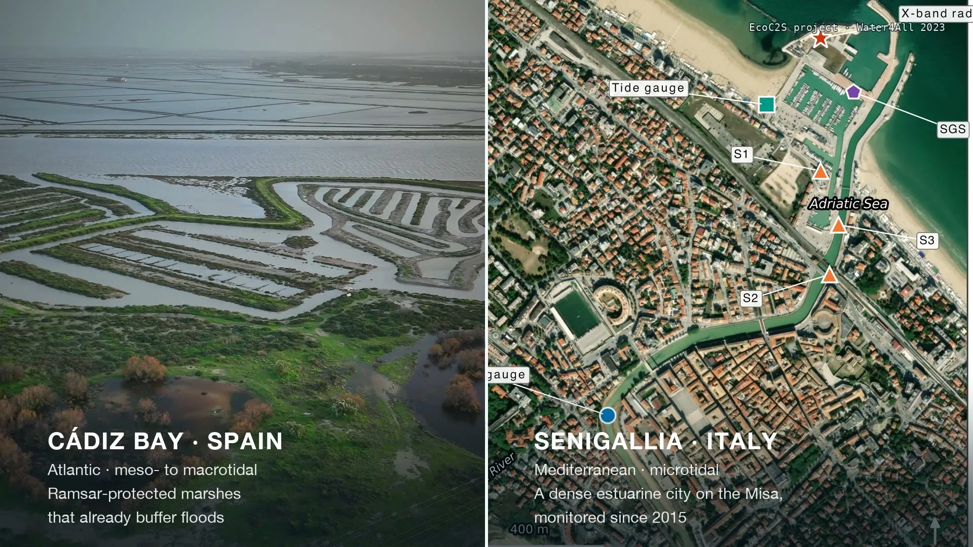
2study sites
Bay of Cádiz · Senigallia
4papers
Published in year one
The challenge
Rain, rivers, tides, surges and waves often strike together.
Their effects don’t simply add up. They amplify each other.
Yet Europe still assesses its flood risk mostly one driver at a time.

The gap
Nature already regulates these floods.
All along the water continuum, from upstream wetlands to tidal marshes and beach dunes, ecosystems slow water down and absorb its energy.
Image: E.P. Morris / University of Cádiz, via ESA
But river and coastal flood regulation have so far been studied in isolation.
EcoC2S joins the two halves.
Our approach
Catchment to sea, as one system.
EcoC2S co-develops a holistic approach to flood risk that quantifies how natural systems and blue-green infrastructure protect transitional and coastal areas.
- 01
Model
One framework for river discharge, tides, surges and waves — and how marshes and sediments respond.
- 02
Value
What wetlands, marshes and dunes actually contribute to flood protection, in physical, economic and social terms.
- 03
Co-create
Resilience pathways built with the communities and institutions who live with the risk.
Study sites
Two coasts, two archetypes.
An Atlantic bay with vast marshes and a Mediterranean river city: opposite on purpose, so that what we learn can travel to other European coasts.

Field & model · February 2026
A real compound flood, hour by hour.
Record rainfall coincided with high tides in the Bay of Cádiz. Our drones mapped the flooded marshes of the Guadalete while the Delft3D model reproduced the event hour by hour.
±0.15 mdifference between modelled and drone-observed water levels
See the Cádiz case studyScience
Four papers, year one.

Communications Earth & Environment · 2025Open access
Where should Europe look first?
A composite index ranks 214 flood-risk areas along 1,600 km of the Spanish Mediterranean coast by their potential for compound flooding.
Del-Rosal-Salido et al. — A composite index framework for compound flood risk assessment

Communications Earth & Environment · 2026Open access
Sea-level rise redraws the map
Projections of how rising seas will change the way rain, rivers and the sea combine to flood the Spanish Mediterranean coast.
Jiménez et al. — Sea-level rise is projected to reshape compound flooding potential in microtidal environments along the Spanish Mediterranean coastline

Estuarine, Coastal and Shelf Science · 2026Open access
River mouths, watched from orbit
34 river mouths, about 100,000 satellite images and nine years show when and why Mediterranean river mouths open and close.
Silva-Santana et al. — Automated detection of river mouth opening and closure using cloud-based processing of Sentinel-2 imagery

Coastal Engineering · 2026Open access
Where waves meet the river
How river currents and sea waves interact at microtidal river mouths — and why their timing decides how far a flood reaches — from a decade of observations of the Misa.
Brocchini et al. — Wave–current interactions within microtidal systems
The film
EcoC2S in four minutes.
A silent film made for the Water4All booth at World Water Week 2026, in Stockholm: why rivers and coasts have to be studied together.
Playing the film loads it from YouTube. No content is loaded from YouTube before you press play.
18 months at a glance
From kick-off to the field.
Apr 2025
Water4All 2023 kick-off
Montpellier, France
Nov 2025
1st Stakeholders Advisory Board
Online
Feb 2026
Drone & model campaign during a real compound flood
Guadalete marshes, Cádiz Bay
Apr 2026
REWRITE local multi-actor lab
Cádiz, Spain
May 2026
First in-person meeting & focus groups
Senigallia & Ancona, Italy
Sep 2026
Stakeholder focus group
Salina de San José, Cádiz Bay
30 Sep 2026
2nd Stakeholders Advisory Board
Online
News
Latest from the project.
 Stakeholders
 Event
 Stakeholders
Consortium
Six partners, five countries.
Expertise in extreme hydrological events, coastal ecosystem services, flood management, risk perception and policy — coordinated by the University of Granada.
 University of GranadaGranada, Spain · Coordinator
 Università Politecnica delle MarcheAncona, Italy
 Universidade Lusófona (COFAC – Cooperativa de Formação e Animação Cultural)Lisbon, Portugal
 Institute of Geophysics, Polish Academy of SciencesWarsaw, Poland
 University of Santiago de CompostelaSantiago de Compostela, Spain
 Karlsruhe Institute of TechnologyKarlsruhe, Germany