CHALCOLITHIC SETTLEMENT PATTERNS IN SYRIA
PATRONES DE ASENTAMIENTO EN LA EDAD DEL COBRE EN SIRIA
Shadi WATFA *
Abstract
In this article we will shed light on the circumstances and primary factors that contributed to the changes in the patterns of settlements in the Syrian region during the Copper Age. We will divide the area under study into geographical regions based on the data available concerning environmental and geographic conditions—factors which contribute significantly to settlements. The division in regions and areas will be crucial to the complete understanding of each region vis-à-vis the archaeological record of the several cultural phases of the broader period under discussion. Understanding this synthesis of the vast and disparate Syrian geography leads us to suppose how the various environmental factors and the ‘trade’ activity of the region in the Copper Age helped determine the founding of each settlement.
Key words
Syria, settlement areas, Copper Age, settlement patterns.
Resumen
En este artículo vamos a arrojar luz sobre las circunstancias y los factores principales que han contribuido en los cambios de los patrones de asentamientos en el territorio de la actual Siria durante la Edad del Cobre. Dividiendo el área en estudio en regiones geográficas basándonos en los datos disponibles relativos a las condiciones-factores ambientales y geográficos que contribuyen significativamente a los yacimientos. La división en regiones y zonas será crucial para la comprensión completa de cada área frente al registro arqueológico de las varias fases culturales del periodo en discusión. La comprensión de esta síntesis de la vasta y dispar geografía siria nos lleva a suponer cómo los diversos factores ambientales y la actividad “comercial” de la región en la Edad de Cobre ayudaron a determinar la fundación de cada yacimiento.
Palabras clave
Siria, Áreas de asentamientos, Edad del Cobre, Factores de asentamientos.
INTRODUCTION
The region comprises a vast geographical area (Fig. 1) that can be divided into several areas, each developing in different ways due to disparate geographical and environmental conditions. Settlement patterns during the Copper Age changed according to social conditions, even so far as to include the concept of urban revolution (LEVÊQUE 1991) taking place due to the emergence of the metal age and subsequent technological inventions this change brought about. The sedentary groups that were responsible for the establishment and development of settlements eventually built walled cities to protect the emerging trade activity (REDMAN 1990; LIUDMILA 2008). From these social changes was derived the introduction of civilization in urban life (CHILDE 1996).
The Copper Age in the region of present day Syria is understood to be the period between 6000 and 3000 BC. and corresponds to three cultural phases (Halaf, Ubaid and Uruk also called the Late Chalcolithic) (MATTHERS 1981: 143; CÓRDOBA 1988: 161; YENER 2005: 195; GEYER et al., 2005: 23; GEYER et al., 2006: 56; MENZE et al., 2006: 321; BANNING 2007: 137; CHRISTIDOU et al., 2009: 319; PARKER 2010: 347; ÖZBAL 2011; LAWRENCE 2012: 121-276; AKKERMANS 2013a: 17).
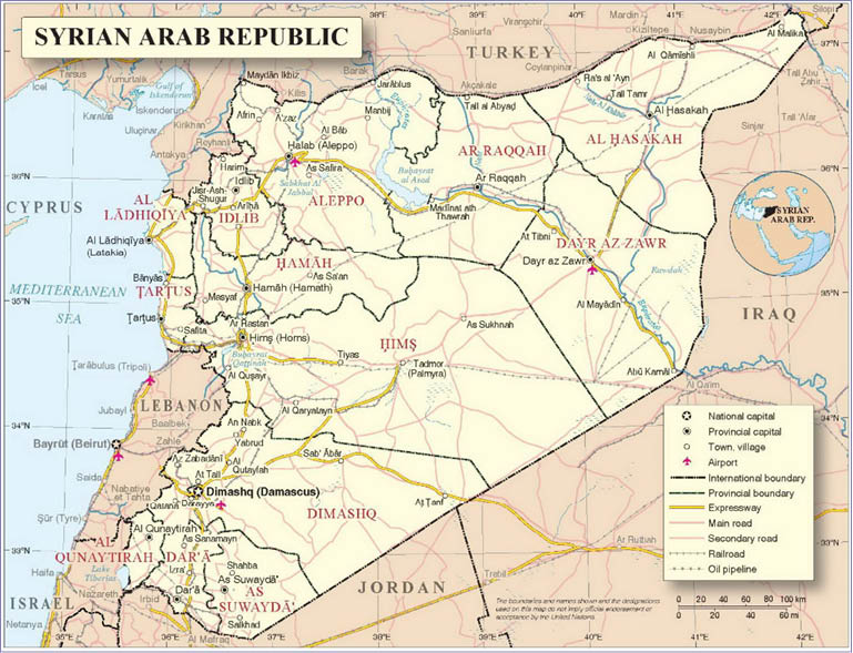
Figure 1. Location of Syria and administrative distribution.
In the settlements of Halaf, Ubaid, and Uruk we find cultures that clearly reflect these societal changes, leading to the formation of nascent states. Evidence of this includes the emergence of cuneiform as a method of documenting and controlling the economic activity in temples. From a distance we can observe several cultural phases -the establishment, rise, and eventual decline of a settlement- when examining the characteristics of each area, even to the extent of almost being able to imagine ourselves in the position of latter inhabitants of each area as they considered advantages and disadvantages of the region and decided to continue in this place or move to another (MANNING 2007).
In the regions of Al-Jazeera (Euphrates and Khabur Balikh), in the northeast of the Syrian area, the Copper Age is divided into three basic phases: Halaf, Ubaid, and the final Chalcolithic/Uruk. Elsewhere, in the northwest regions of Syria are Al-Amuq, Qoueiq, Jabboul, etc. Prehistoric temporal sequences have been categorized as Amuq C, D, E, F, and G (BRESSY et al., 2005; YENER 2005; ÖZBAL 2010a).
LAND AND SETTLEMENT: KEY ISSUES ON DETERMINING FACTOR SETTLEMENT AND AREAS
Before beginning to discuss the factors that determined settlements of the Syrian regions during the period of our study, we should first define the concept of settlement. Then we can discuss more clearly the conditions that may be favorable or unfavorable for locating a settlement in a specific area.
The term settlement refers, in archeology, to an inhabited area used by a particular human social group (VALENTÍN 1982; GEYER et al., 2006). It may vary in size and constitution based on the economic activity and seasonal mobility of the inhabitants, and the ways in which they intervene physically with their natural environment and how they integrate and configure their social identity (SÁNCHEZ 1991).
The existence of a settlement in a given area is influenced by factors related to methods of interaction between humans and their geographical environment; human needs and the features of the physical environment determine whether a settlement might develop (VALENTÍN 1982, ANSCHUETZ et al., 2001). We will consider the factors that determine the foundation of a settlement: geography, terrain, climate, vegetation, and hydrography.
1. Geographical factors: The ancient area of Mesopotamia was strongly identified through its inhabitants and their relationship with the geography, the stark contrasts between populated and unpopulated areas, and by factors that presented environmental conditions of extreme adversity (ARDELEAN 2004; Ur, 2010b) (Fig. 2).
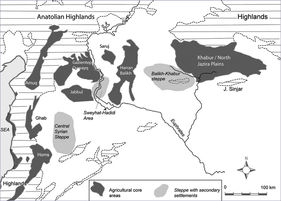
Figure 2. Agricultural areas and areas of secondary settlement (Wilkinson et al., 2014: 95).
2. Orographic factors: The region of our study is characterized by a mountainous area in the west, delineated into three zones: Southern, Northern Mountains and Lineups Mountains. Also notable in the region of study are the steppes and desert areas, Shamiyya and Mesopotamia, and areas of valleys and coastal salt lakes. These areas have desert plateaus ranging in altitude between 800 and 1800 meters (VV.AA., 1990; SWEENEY and WALTER 1998).
3. Climatic factors: The area has a continental and Mediterranean climate with poor hydrography (MANZANILLA 1988; MCCORRISTON 1992). Vegetation varied widely due to natural causes: climate, topography, soil, and the distribution of phytogeography throughout the several regions (GEYER et al., 2006). Between the period of the Glacial Maximum and today there has been a marked evolution in climate. The greatest changes occurred during the late seventh and fourth millennia BC, bringing sudden changes in temperature and rainfall, affecting the extant societies to a greater or lesser degree depending on the region and methods of sustenance, but directly and significantly affecting agricultural activities in northern Mesopotamia. As a result of poor hydrography at the beginning of the Copper Age, the population was dependent on irrigated agriculture, pastoral nomadism, and migration (Weiss, 2003). Population declined in many sites, even including abandonment of regions of the north, especially in the basin of Al-Rouj (IWASAKI and TSUNEKI 1999) and parts of northern and central Mesopotamia and Al-Ahmar Wadi (BECKER 2006; STAUBWASSER and WEISS 2006). Also notable is how the development of agriculture strongly affected settlements as well as led to deforestation and overuse of soils. We also note the abandonment of some cultivated areas as the populations relocated to areas to take advantage of their milder climates (REDMAN 1990; MILLER 1997).
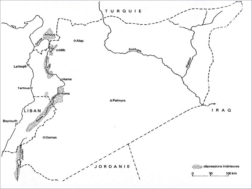
4. Hydrographic factors: There is a direct relationship between the availability of water and the foundation of settlements in the area under discussion (VIOLLET 2004; CRUELLS and MOLIST 2006). Primary sources of ground water in the region are from the major rivers: The Orontes, Qoueiq, Tigris, and Euphrates, in addition to their tributaries. The Euphrates River comes from an alluvial formation on the floor of a valley. In the ninth millennium BC (GEYER and BESANÇON 1996) the perennial stream Balikh had a three to five cubic meter per second flow over a hundred kilometers from the highlands of the Taurus Mountains (WOSSINK 2010). The Orontes River was a vital communication route and was used to control exchange activities between the north and south of the region of northwest Syria (Fig. 3). Its depth varied between 0.9 and 1.8 meters depending on season, summer or winter (CASANA and WILKINSON 2005). The Khabur River provides favorable soil for non-irrigated agriculture (especially cereals) with seasonal water supply from Tur Abdin Massif (MCCORRISTON 1992).
Societies in Transition
The transition from unorganized settlements to societies was spurred by favorable environmental conditions with varying effects and adoption rates according to the settlement area. The pursuit of development was favored by the existence of fertile soil in river basins that brought agricultural development and animal husbandry, as well as the development of urban life (MANZANILLA 1988; ZEDER 1994; CHILDE 1996). The Copper Age was marked by increased settlement of river areas in the vicinity of Khabur, Balikh, and Upper Euphrates Amuq, where sites have been found and dated to between 5800 and 3800 BC. There was a seasonal mobility for strategic area in order to control resources in northern Syria around the Khabur River (VAN ZEIST and WOLDRING 1979; ZEDER 1994; BARREYRA 2001).
The change in economic trends brought not only modifications of agricultural activities but also development of, and greater trade in textiles, masonry, pottery, and obsidian (PICON and LE MIÈRE 1987; ÖZBAL 2010b). All this took place in conjunction with a prior exchange dynamic responding to changing needs, focusing on specialization and concrete manufacturing (PARDO 2001; BRESSY et al., 2005; NIEUWENHUYSE 2010). During the Halaf, Ubaid and Uruk cultures trade routes extended dramatically (PARKER 2010); we find evidence of this in ceramic remains and the morphology of access and communication exchange routes. Trade was carried out on river routes or overland by nomadic or semi-nomadic people. However, it should be noted that the use of river transportation remains conjectural as no archaeological evidence exists to suggest the use of boats for transport, for example, in Tell Mashnaqa and the private port Habuba al-Kabira (THUESEN 1996).
The growth of trade activity in building materials and objects became a determining factor in the establishment and growth of new settlements (SHERRATT 2005). These were mainly in key areas where proximity to sources of raw materials such as obsidian (exploited during the Copper Age) and metals (CAUVIN et al., 1997), as well as to the trade routes were the decisive factors for the location or relocation of settlements (REDMAN 1990).
In this regard, it is important to emphasize the development of these activities during the Halaf phase as this allowed populations to expand to more remote areas (MCCORRISTON 1992) such as the coast, the mountains of Central Anatolia, and Mesopotamia (MOLIST et al., 2007; GAULON 2010; ÖZBAL 2010b). Indeed, obsidian was a key player in the development activity of the period of Pre-Halaf, from Nenezi Dag (Cappadocia, eastern Anatolia) (CAUVIN et al., 1997; BRESSY et al., 2005).
Subsequently, during the Uruk phase, we note through the analysis of ceramic styles, a rise in trade activity and its reaching out over longer distances for new trade partners, even insofar as crossing the Euphrates and its tributaries from southeastern Anatolia to the south (northern Mesopotamia) (STEIN 1999; MAZZONI 1999) to sites such as Al-Kabira Habuba, Jabal ‘Aruda, Tell Qannas, Jarablus, Halula, Zeidan, Hamoukar and Tell Brak. These areas had a high demand for building materials such as wood, metals (copper, silver, and lead), and minerals, especially gypsum, alabaster, flint, and semi-precious stones (lapis lazuli, rock crystal and jasper).
In these sites we observe also the existence of other forms of penetration into the settlement from branch access doors; hence the strategic importance of these in terms of location for better control of the production and migration routes (SANMARTÍN and SERRANO 1998). The best example of this we find on the Orontes River area, Al-Amuq and Tell Afis that were located at the crossroads formed by the trade routes from the Taurus Mountains to the Plateau of Anatolia and the Mediterranean coast (MALLOWAN 1967; CASANA and WILKINSON 2005; BRESSY et al., 2005).
SETTLEMENT AREAS
In this section we will give a clearer picture of the most important Copper Age sites in Syria, grouped by major regions in order to better understand the geographical area of each site through its archaeological records. We will examine this subject region by region, observing individual areas, highlighting information related to settlements in the following tables.
The first region (I) is northeast of Syria, known as Al-Jazeera. One of its most notable features is the presence of river valleys of the Euphrates, Al-Balikh, and Al-Khabur and its tributaries. The second region (II) in the Syrian Northwest includes several areas: the Qoueiq Valley, Lake Jabboul, the Al-Rouj basin, the Syrian coast, and finally the Orontes River, from its entry into the Syrian territory to its mouth in the Mediterranean basin, Al-Amuq. The third region (III) includes the basin of Damascus and the Golan Heights southwest of Syria. The fourth and final region (IV) coincides with the course of the Euphrates from the city of Deir Ez-Zor to the Syrian-Iraqi border and the area of Al-Kowm in the Midwest (Map 1).
Region I: Al Jazeera: This is situated in the northeastern Syrian territory from the Euphrates River west to the Tigris River and east Syrian-Iraqi border. It stretches north along the Syrian-Turkish border in the highlands of Tur Abdin. Going in a southerly direction, it ends just to the north of the city of Deiz ez-Zor. Here we have an environmental dichotomy; from the north with its semiarid climate to the south with fertile land suitable for agriculture (HOLE 2009). On a high plateau of fertile soil between 350 and 500 meters above sea level, this area forms a platform of arid steppes whose environmental context is very different from that of southern Mesopotamia (WILKINSON et al., 2004; UR, 2010a).
- Upper Euphrates (Map 2): This includes the Euphrates valley between the city of Jarablus and the confluence of the Khabur situated toward the south, in proximity to the city of Al-Raqqa. The river flows through a series of mostly broad valleys where periodic flooding enriches the terraced land.
With respect to both the north-south extension as well as the descent of the river from the Taurus Mountains toward the desert steppes, weather conditions vary widely and lead to disparate natural vegetation, agricultural practices, and therefore, a wide range of livelihoods of the populace. Rainfall varies from 400 mm per year in the north to 250 mm in the south, from the sector of Carchemish to Tell Es-Sweyhat respectively (TOUEIR 1983; HASSAN 1995). The study of the sites in this sub region was favored by the construction of dams in 1970 and 1990, giving impetus to rescue excavations (TOUEIR 1983, MONTERO 2006; LAWRENCE 2014). According to archaeological data (Table 1), settlements in the Upper Syrian Euphrates date back to the Upper Paleolithic period, while those from the Copper Age have been registered in several areas including Halula Tell, Tell-Amarna, Suweyhat (Halaf) (TOUEIR 1983), Tell Hassan Sheikh, Mureybet, ‘Anab Al-Safina (BOUNNI et al. 1974), Tell Al’ Abr, Kozak Al-Shamali and Tell al-Haj (Ubaid) (STUCKY 1975; SUDO 2010). From the phase of Uruk we find the main occupations are at Tell Sheikh Hassan Al-Kabira Habuba, Tell Qannas, Jabal ‘Aruda, and Tell Hadidi (WILKINSON et al., 2004).
- Al-Balikh (Map 3): This region is drained by numerous canals and streams, and again, we find vast differences in the land from north to south. Rainfall varies from 183 mm in Al-Raqqa near the Euphrates to 275 mm near Tell Abyad (Hassan, 1995). The region’s water comes mainly from the spring of Ain-al Arous. The northern regions are favorable for non-irrigated agriculture, while the south requires irrigation. It encompasses a large area -100 km from north to south- but that has not inhibited good communication routes even since ancient times (Córdoba, 1988; Wilkinson, 1995). Successive excavations since 1925 suggest occupation from the Neolithic period (Table 2) and the sites of Tell Asouad (Neolithic Halaf), Tell Sabi Abyad (Pre-Halaf, Halaf) Munbata Tell, Tell Rijiliye, Al Bassal and Tell Shahine (Halaf) Mafash Tell, Tell As-Sawan and Tell Zeidan (Halaf, Ubaid), Hammam al Turkman (Ubaid), Tell, and Tell Gidla Bi’a (Uruk) provide a chronological sequence of occupation of this area (BESANÇON et al. 1982; AKKERMANS 1987).
- Steppes of Balikh-Khabur (Map 4): Between the Balikh and Khabur rivers lies a vast plain where rainfall is between 200 and 300 mm annually. While there have been few archaeological digs (Table 2), we know that humans have occupied the region from the Paleolithic period onwards and that there were more permanent occupations during the Halaf and Ubaid periods (BECKER and HELMS 2013; WILKINSON et al., 2014).
- Al-Khabur (Map 5, 6 and 7): Geomorphologically, the area is relatively homogenous, composed of a wide, undulating plain. Its irrigation comes from the Jagh-Jagh River, but there are also a number of perennial and seasonal watercourses that flow into the Khabur River (HASSAN 1995; LAWRENCE 2012).
The climate of the area is Mediterranean, with increasing aridity as we move from north to south. Rainfall varies from a maximum of 500 mm in the north to 150 mm in the south, mostly falling during winter. Summers are very dry (UR 2010A; LAWRENCE 2012). The land of the Upper Khabur, as a whole, is very productive, but in the southern regions agriculture is restricted to the margins of river areas (UR 2010a).
The different cultural phases show changes based on a transition between the Proto-Hassuna and early Halaf, visible in the transformation of cultures through the gradual intensification of exchange indicated by significant sharing of culture material (LE MIÈRE and NIEUWENHUYSE 2000). During the Halaf period we notice a gradual extension of settlements to the south (AKKERMANS 1989), in addition to the existence of several sites of great size showing that the society was much more complex than initially thought (Table 3). The Ubaid period is characterized by predominantly small villages, although there were some large settlements. In periods of Ubaid and Uruk, we find two phases of a long period of cultural intrusion in which northern Mesopotamia adopts characteristics from the south (LYONNET 2000).
Region II: The Syrian Northwest is delimited by the Euphrates Valley on its eastern side to the Mediterranean Sea on its western. Its subdivisions are the Jabboul area, the Qoueiq Valley, the arid plains of northwestern Syria, the Orontes River, the Amuq plain, and the Syrian Littoral Coast. The western part of this region coincides with a Dead Sea valley fault zone, where the African and Arabian plates meet. The collision of the two plates, creating the coastal mountain ranges, causes a division or barrier between the interior and the coast. These are the mountains of Lebanon and Anti-Lebanon Nusayriyah. This orographic formation is caused by the Orontes River which flows north from its source in the Bekaa Valley before turning towards the Mediterranean Sea (HASSAN 1995; LAWRENCE 2012) (Fig. 3).
The climate of this region varies widely from one side to the other. Aridness becomes more pronounced as we move from the west coast to the east on the plains and steppes. The rainfall levels vary from highs in the Amuq area of 1800 mm to lows in Jabboul, where averages are only 200 mm per year (LAWRENCE 2012). Despite the lack of archaeological research, excavations reveal how the site of Amuq belonged to the Halaf, Ubaid, and finally Chalcolithic periods, allowing a chronological division from the Neolithic to the end of the Bronze Age (ca.6000-2000 BC) (YENER 2005; GERRITSEN et al., 2008).
- Orontes area (Maps 8, 9 and 10): Dominated by lake beds, this valley around the city of Hims consists of three main physical regions: the Orontes Valley, the agricultural plain to the east, and a basaltic upland region to the west of the river caused by tectonic activities (WILKINSON et al., 2014). In the eastern part, with a landscape of marl descending from southeast to northwest, annual rainfall is between 300 mm and 500 mm. passing through the Valley Amuq in its final length, the Orontes River crosses a plain of about 40 km2 at 80-85 m above sea level (HASSAN 1995). Water for the plain is drawn from three rivers, the Orontes, flowing north from Lebanon connecting to its tributary, the Afrin River from the northwest (Turkey), and Kara River, which originates at Lake Van in eastern Turkey.
The region receives annual rainfall of between 500 and 700 mm (YENER 2005). The valley of Al-Amuq is an important region geographically, being a primary route connecting the highlands of Anatolia to the high Mediterranean west through Mesopotamia. There is evidence of trade networks from the Neolithic period, with the clearest appearing in the Amuq phase, phase A/B, with the southern areas along the Mediterranean coast which were supplied with obsidian from central and eastern Anatolia (PAMIR 2005).
In the lower Orontes region are recorded specific Chalcolithic occupations in the areas of Hims (Table 4). Known sites are of three, five, and nine hectares in size, and are found concentrated along the Orontes. Tell Nabi Mend is the largest of these sites (Balbo et al., 2009; Wilkinson et al., 2014). Ceramics dating from the Copper Age, the fourth millennium (ca. 3700 BC), have been found here. Surveys made by Bartl and Maqdissi between the present cities of Al-Rastan and Hama suggest a very low density of settlement during the Copper Age between 6000 and 3500 BC (LAWRENCE 2012). Hama, the dominant site for many years in the Orontes Valley, has been brought to the forefront by the excavations of Mallowan, (1967) showing a long sequence of occupation dating from the Neolithic to Bronze Age (Halaf, Ubaid and LC).
In the Amuq area 178 sites have been registered dating from the Neolithic to the Islamic period (Mallowan, 1967) with no evidence of occupation previous to Amuq A except Tell Kerkh in the Rouj Area, 70 km to the south (MIYAKE and TSUNEKI 1996; COPELAND 1981; CASANA and WILKINSON 2005). Between phases A and C there is an uneven spread in settlement size (maximum of one hectare) (CASANA and WILKINSON, 2005) with the exception of Tell Kurdu which extended to 12-15 hectares during the phase of Amuq C (YENER 2005; GERRITSEN et al., 2008).
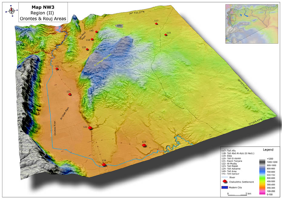
In the South of the Amuq Valley, in a basin called Al-Rouj, there are 33 sites documented by research conducted from 1990 to 2002, first by the Japanese University of Tsukuda (IWASAKI and TSUNEKI 1999; TSUNEKI et al., 2005) and later between that university and the Syrian Directorate General of Antiquities. There is no evidence in Amuq of occupation during the Paleolithic period, although surveys on the above sites show a long succession of occupation from the Pre-Pottery Neolithic period (PPNB) to the Copper Age (BESANÇON and GEYER 1995). Similarly alluded to in the studies is a decrease in the number of sites from 16 in the Neolithic period (phases Rouj 1 and 2) to only five in the Copper Age (phases: Rouj 3 and 4) as well as a decrease in the area from ten hectares in the Neolithic to six hectares in the Copper, probably due to climate change, as pointed out by Iwasaki (IWASAKI and TSUNEKI 1999).
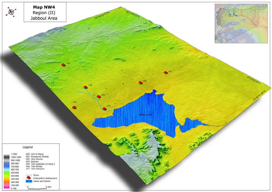
- Jabboul Area (Map 11): Jabboul Lake extends from the river Nahr al-Dhahab west to the east of the Euphrates River (35km) and from Lake Jabboul south to the mountainous arc around it. The topography of the area consists of a flat limestone plain whose soil is rich in calcium aridisol caliche. Today precipitation decreases from west to east; from 300 mm near Nahr Al-Dhahab to 200-250mm near the Euphrates Valley (Schwartz et al., 2000). The region comprises a total of 144 sites, showing continuous occupation since at least the Neolithic period based on documented materials discovered at the sites. Again, we identify the different periods of occupation through analysis of ceramics; five settlements in the Neolithic period (ca. 6000-5500 BC) are known, three sites in the Halaf period (ca. 5500-5000 BC), and up to seven during the Ubaid (ca. 5000-4000 BC) (Table 5). These settlements were located mainly along the river Nahr Al-Dahab on the western edge of Jabboul (Judeideh, Abu Danna and Um al Mara) (SCHWARTZ et al. 2000).
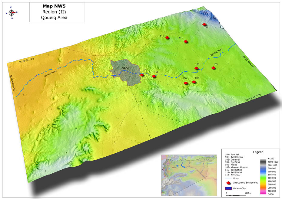
- Qoueiq (Map 12): Located in the triangle formed by the cities of Aleppo, Bab, and Azaz, its major river, of the same name as the area, has its source in the Gaziantep Plateau and courses over a distance of about 35 km in Turkish territory. Qoueiq covers an area of 135 km north to south and approximately 40 km wide near the Syrian-Turkish border. Precipitation is between 600 mm and 380 mm annually (DORRELL 1981; MATTHERS 1981). Excavations here show evidence that the Qoueiq Valley has been exploited since the Paleolithic period (Table 6), with the earliest evidence of human civilization at the site of Tell Qaramel from the PPNB period. Later sites are more numerous and seem to cluster along the banks of streams and tributaries. As in other areas, an increase in settlements during the Copper Age has been documented, especially notable in its final phase (MATTHERS 1981; COPELAND 1981).
- Arid steppes: Divided into a 10.800 km2 area of southern Jabboul Lake and Alepo city. The region receives 200 mm of rain annually. Its first settlements date back to PPNB, located mainly in areas where there was easy access to water, offering opportunities for development. Here there are no known sites from the Copper Age (Halaf, Ubaid, and Uruk phases), but only from the Bronze Age onwards (GEYER et al., 2005; GEYER et al., 2006; JAUBERT and GEYER 2006).
- Littoral (Map 13): This is a fairly narrow plains area, about 150 km in length, with a Mediterranean climate, warm and humid, with annual rainfall of about 800 mm. (VV.AA., 1993) Archaeological studies show how the Syrian coast has been occupied since the Paleolithic (Table 7) (Qal’at Yahmour), Neolithic (Tabbat Al-Hammam, Ugarit etc.), and Copper Ages. (Qal’at Al-Rus, Sukas, Abu Ali, Tell Kazal, Tabbat Al-Hammam and Ugarit) (DE CONTENSON 1970; SANLAVILLE et al. 1994; AL-MAQDISSI 2003).
Region III: The Southern zone, comprising the basin north of Damascus, the mountain of Al-’Arab to the east, Golan to the south, and in the center, Huran Mountain (ABD EL-SALAM 1989).
The Golan area (Map 14) with its natural boundaries, the Golan River, Lake Tabareya, and the Jordan River, occupies an area of 1,860 km2. We have insufficient archaeological information about the occupation during the Copper Age from this area due to an insufficient number of archaeological excavations (DE CONTENSON 1985). There are rare examples from the Damascus area (Map 15), such as the sites of Tell Ghoraife and Tell Aswad (DE CONTENSON 1975), both important due to data that indicates the emergence of human occupation of the zone that included agricultural activity and animal domestication. Further, there is scant information of the Neolithic period in the provinces of Dar’a and Al-Swaidaa, but surface findings point out the importance of agricultural clusters in this area. The sites date back to the Copper Age, where the most important are Khirbet al-Umbashy, Al-Habareya and Tell Ashtara (BRAEMER 1984; BRAEMER et al., 1993; MUHESEN 1997). The first demographic agglomerations date from the fourth millennium BC when significant changes occurred in agricultural production, particularly its intensification due to the good soil quality (VAN-ZEIST and BAKKER-HEERES 1979; MUHESEN 1994).
Southern Syrian sites date to the Copper Age. For this knowledge we attribute the discovery of Father Josef Nasr Allah in Dar’a (NASRALLAH 1956). The find was made in the first half of the twentieth century, indicating monuments of Ghassul culture, various stone tools, hunting implements, evidence of leather manufacturing, and agricultural tools similar to those found at the site of Tulailat al-Ghassul. Since Israeli occupation of the Golan Heights in 1973 (KHADOUR et al., 2013), excavations carried out by archaeologists have revealed 25 settlements from the Copper Age (Table 8), including scattered farms from the Jordan River in the west to the river valley east of El-’Al (KAFAFI 2010).
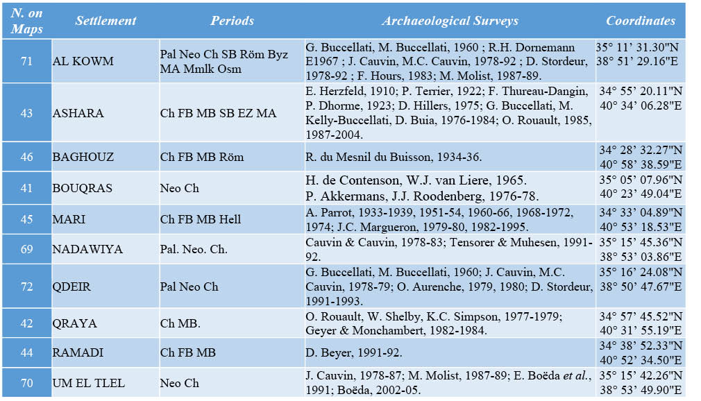
Region IV: Al-Kowm (Map 16), about 25 km wide and 40 km long, is an oasis located in Al-Badia, between the Euphrates and Palmyra, surrounded by the mountains of Minshar and Mqaibara in the south and Jabal Bishri in the northwest (MOLIST 1984; BOËDA et al., 1999). This region has an arid climate with a very low average annual rainfall of only about 130 mm. Permanent underground sources of water made human settlement possible in these areas since the Paleolithic period (MOLIST, 1984; LE TENSORER ET AL., 2003).
In the Al-Kowm area we find two settlements known as Al-Kowm I and Al-Kowm II. The first was abandoned near the eleventh millennium BC and then reoccupied between 7000-6500 BC. This site is well known as one of the first places in the Middle East where infrastructure was built for public use (VIOLLET 2004).
Excavations of Al Kowm II in 1978 by D. Stordeur (1989) reveal that it spanned an area of two hectares. The occupation of this settlement can be divided into three phases: The first two occurring near the end of PPNB and ceramic Neolithic; the third phase corresponds to the Uruk period.
- Lower Syrian Euphrates area (Map 17): This area encompasses the Euphrates route between the towns of Deir Ez-Zor and Al-Bukamal near the Syrian-Iraqi border. Annual rainfall is slight, at only 133 to 159 mm on average (Rouault, 1998). This region has undergone fundamental changes in climate since the time of the Neolithic period where settlements were found on the margins of the valley. Harsh weather conditions relegated agricultural activity to very specific areas, and because of this, there were no more than two settlements during Neolithic times. However, during the Copper Age conditions changed due to two main factors. The first was the existence of alluvial plains which made the area easily accessible and fertile. Second, was the development of improved agricultural techniques and irrigation. Tell Ramadi and Baghouz (Table 9) are the best examples of settlements in the area (GEYER and MONCHAMBERT 1983; GEYER and BESANÇON 1996; ROUAULT 1998; NIEUWENHUYSE 1999).
CHRONO-GEOGRAPHICAL DISTRIBUTION OF SETTLEMENTS
Our description of the regions of ancient Syria and their patters of settlement should also include a chrono-geographical analysis of the area during the Copper Age. As the age progressed, the region experiencing increasing population and occupational diversity, mainly in the river-coastal regions and the steppe between 8000 and 7500 BC (STORDEUR and ABBÈS 2007).
Between 7000 and 5500 BC, this demographic trend continued in a number of settlements which rose rapidly and declined with equal velocity. In our chronology we may distinguish various periods, beginning with the period of Halaf (ZEDER 1998; STORDEUR and ABBÈS 2007). We have archaeological evidence that this culture was not the result of movements of nomadic groups or migration of foreign populations, but the result of incremental relocations of sedentary groups from disparate regions (DE CONTENSON, 1996; MOLIST et al., 2013). Following the lead of earlier investigations we distinguish these phases:
Pre-Halaf (6100-5850 BC) (CRUELLS 2009), Settlements were situated alongside the rivers Khabur and Balikh on the north (COPELAND 1979), and characterized by primarily agricultural occupations. The number of settlements was small, and none exceeded one hectare in size (LEE et al., 2008; RUSSELL 2010; AKKERMANS 2013a; id, 2013b).
The Halaf 1 (5580-5700) (CRUELLS 2009), during this phase the number of settlements in the Khabur Valley increased, in contrast to those of Khabur and the Euphrates region, which remained comparatively constant (AKKERMANS 1989). The settlements were more highly concentrated in the north; many of them newly built, some re-occupied after a period of abandonment, particularly in the Balikh Valley. According to Akkermans (1989), this was due to climate change and the development of new technologies for water control. Settlements of this region had a maximum size of one half hectare and were occupied by nomadic groups. There is evidence of settlements elsewhere -Munbata, Qardana Tawila, Sabi Abyad in the Balikh area and Nisiben in the Khabur- that spread over an area of between 1.2 and five hectares (RUSSELL 2010; ÖZBAL 2010B; BECKER and HELMS 2013).
During the period of Halaf 2 (5700-5550 BC) (CRUELLS 2009), we observe an upturn in population in the valleys of the Euphrates in the north and Khabur Balikh in the south, despite the dry climate, unfavorable to agricultural activity. These settlements were also normally small in size, not exceeding one hectare. New settlements were established during this period; among these were Khirbet al-Shanaf, Shams Al-Din Tnanira, Qseir Um, and Kashkashouk (DE CONTENSON 1996; TSUNEKI 1998). There were, however, exceptions to the tendency of small settlements. Among this group are Tell Es-Sawwan (Balikh), Munbata and Nisiben (Khabur), Kurdu (Amuq), each reaching almost 17 hectares (ÖZBAL 2010B; GAULON 2010).
The period we know as Halaf 3 (5550-5300 BC) (CRUELLS 2009) is characterized by the diffusion of Halaf cultural traits, such as specific types of ceramics, and building styles and materials reaching Ras Shamra to the west, northward reaching Girikihaciyan Tilkitepe, and southward to areas without permanent settlements (GAULON 2010). During this phase we see the continuation of the trend toward a reduced size of many settlements (UR 2010b).
Between 5300-5050 BC (Cruells, 2009) there is a transition period between the Halaf and Ubaid periods. The cultures of this time span elude easy definition because of their social, productive, and artistic similarities, and the fact that settlements overlapped the different phases of these two periods of history (KARSGAARD 2010; BECKER and HELMS 2013), characterized by the contrast between the large number of small settlements and those larger, but fewer in number. The largest settlements of this period are those found in Khabur and the Balikh (MCCORRISTON 1992; GAULON 2010).
Ubaid (5050-4100 BC) (CARTER and GRAHAM 2010): The Middle Chalcolithic period begins with the Ubaid culture, moving forward from the Halaf that was characterized and heavily influenced by migration and cultural exchange (AKKERMANS and SCHWARTZ 2004; CARTER and GRAHAM 2010). Based on the archeological evidence and the study of DNA from several settlements (ÖZBAL 2010a), we can conclude that this was a peaceful time, a conclusion strengthened by the evidence of continuity and social stability of the settlements from pre-Ubaid to Ubaid in the area, with no indication of migrations from southern Mesopotamia (CARTER and GRAHAM 2010). Early inhabitants had the advantage of living along the Euphrates and on the banks of swamps, giving easy access to water. We find them making more use of ceramics, as well as farm technology such as sickles, axes and other tools of baked clay, such as for spouts (REDMAN 1990; AKKERMANS and SCHWARTZ 2004). The settlements of this era reach a size of between 2.5 and 15 hectares, taking a step forward toward the formation of urbanism (TRENTIN 2010; UR 2010b; LAWRENCE 2012; STEIN 2012; BECKER and HELMS 2013). This development reaches its peak around 4500 BC, and is the direct predecessor of Sumerian culture. The phenomenon of an urban society is found at the site of Tell Brak where its suburbs cover some 130 hectares (UR 2010B; UR et al. 2007). Here we find the evidence of factors that promote population growth: previously nomadic or semi-nomadic tribes trending toward a more sedentary lifestyle, and the migration of these peoples from the mountainous north to areas that are able to sustain agriculture and irrigation, taking advantage of technological advances in farm technology and ceramics (ROUX 2002; UR 2010b).
In the final Chalcolithic period, the Uruk culture attains its maximum geographical reach, extending from the Mesopotamian River south into northeastern Syria (STEIN et al., 1999). This society now tends to become more complex as evidenced by the increasing diversity of occupations (MCCORMICK and NISSEN 1972). New settlements- Habuba al-Kabira, Tell Qannas and Jabal ‘Aruda (VALDÉS 1996)- have been identified as trading colonies whose main concern was to control the trade routes, inter-settlement communication, and the extraction of high-value materials from resource-rich areas (WEISS and COURTY 1993; ALGAZE 1986; STEIN 2012; ALGAZE, 2013). Most of these sites of commercially prominent nature have been found on the Euphrates and Khabur and its tributary, the Balikh (STEIN 1999; STEIN ET AL. 1999; WEISS and YOUNG 1975; VALLET 1996; ALGAZE 2013).
Advancing agriculture, craft, and trade activities were new developments in this period. New technologies of wheeled carts, sleds, and sailboats appeared (Redman, 1990; Roux, 2002). Exchange was practiced over long distances, art developed through the use of metal as a new raw material and we observe the use of luxury items such as stone and bronze vessels even in the small villages. These advances lead to the creation of the so-called “state governed cities” (UR, 2004; id., 2010b) that, in turn, lead to conflict due to land and water issues (REDMAN 1990).
We have limited data concerning the northeast and southwest regions of Syria in the Copper Age despite the number of excavations and findings. The primary factor in the location of these settlements was the availability of water resources for the development of agriculture and especially grazing in the southern plains (GEYER and BESANÇON 2002). We find throughout most of the Copper Age that settlements did not exceed three hectares (WILKINSON et al. 2014) except those few settlements such as Tell Kurdu (Amuq), Tell Nabi Mend (Hims), Abd Al-Aziz (Al-Rouj), and Judaideh (Jabboul).
To complete our chrono-geographical overview, we also note the shortage of settlements in the West Syrian Steppes (east and northeast of the city of Hama) (DE CONTENSON 1982), even when this area was within the pottery distribution circuit of the Halaf and Ubaid cultures (GEYER et al. 2006). A hypothesis for this dearth of evidence of settlements may be that there were only temporary settlements connected with the middle areas of the Euphrates (MUHESEN 1999; GEYER and BESANÇON 2002; CASANA and WILKINSON 2005).
INTERPRETATIONS
The Copper Age in a given geographical area is defined by a general perspective of a period of great changes and transformations reflected in the rise of metallurgical knowledge and activity and the consequent development of useful objects that facilitated the performance of the functions of everyday life. Among these are counted the wheeled cart, the potter’s wheel, and new techniques for extracting mineral resources. These advances were produced in a chain of events-steps of human progress leading to improved living conditions. The first changes were due to the progression toward a sedentary lifestyle, which was accompanied by activities that promoted the exchange of diverse products. Finally, agriculture and livestock arrived on the scene, bringing an increased supply of readily available stocks of food and reducing dependence on hunting and gathering. The exchange of goods then created a closer relationship between people who traded by bartering raw materials, ornaments, and luxury items, which, together with the normalization of trade routes created to move the products, resulted in the creation of core population centers that became the backbone of the societies of the Copper Age.
The high percentage of sites found in the vicinity of Balikh (GAULON 2010) establishes a clear link between the formation of Chalcolithic and Neolithic sites in northern Syria and the environmental factor most responsible for the possibility of settlements: water resources (AKKERMANS 1989). The precise mechanisms of change that moved societies from the Neolithic to Copper Age -the emergence of a sedentary lifestyle, agriculture, livestock, and trade and its consequences and benefits- is not entirely clear. The most we can say is that it is in the Copper Age when man begins to dominate copper without neglecting traditional stone work. The Halaf period mentioned above is a reference to this time. The technical advances in agriculture bring with them a higher rate of productivity and a concomitant supply of food stores. From here we see the expansion of the population due to greater food supplies and routes of exchange, driving the ability to expand into other productive capacities as food surpluses were exchanged for non-food necessities that might include minerals and any number of other goods unavailable in the local vicinity.
The growing populations followed traditional settlement patterns such as the aforementioned search for locations near watercourses to support the requirement for drinking water as well as agricultural production. It is difficult to establish which factors are primary and derivative in the creation or disappearance of settlements, but we can observe the systematic mechanisms through which factors interact.
In the Ubaid period the exchange of goods increased, as did the use of waterways to support demographically dense areas. Exchange became an essential part of the activities in economic terms at the end of this time with the intensification of trade between the north and south. Later, with the appearance of the Uruk culture, the most notable and significant change is the birth of urban centers, leading to societal stratification and, indeed, a new way of understanding society. Possibly this was due to the control of trade routes which then created larger conflicts within and between settlements and larger urban areas. It is this progression from small villages to the formation of cities, with a transformation of an increasingly stratified societal organization that brought about the creation of defensive systems and the need to forecast, and more importantly, fortify against potential economic and other threats. Along with organized trade, the use of armories to supply armed (LIUDMILA 2008) detachments and the establishment of power centers connected directly with the elite came to be the main features of Mesopotamian civilization (STEIN et al., 1999; LIUDMILA 2008). Uruk, Habuba Al-Kabira, Jabal ‘Aruda, Qannas Tell, Tell Brak, Hamoukar and Tell Carchemish all possibly comprise a comprehensive settlement for the purpose of controlling trade activity.
This region supplied a large variety of resources for potential exchange, especially coveted obsidian, appearing in the towns of Halaf. Evidence of white marble, clay, loam, and gypsum minerals such as chlorite, wood, flint and quartz is found in various sites from the Persian Gulf to Anatolia, and throughout the Syrian Desert areas (MOLIST 1996).
As M. Molist (1996) pointed out, in Tell Halula there is evidence of large-scale exchange activity with other communities in products such as obsidian. Moreover, Tell Sabi Abyad is considered to have played an essential role as a consumer of raw materials for the purpose of subsequent manufacture of more elaborate goods. We observe a key event in the development of Copper Age settlements when they began linking trade routes to the north toward Turkey, south toward the region of Sumer, and toward the Syrian inner-west, becoming strategically important as trade centers and promoting the growth of trade and commerce. The development of this trade activity and the growth into regional trade centers did not occur without difficulty, since the main cause of conflict was precisely the trade activity and, attached to it, the need to control the routes by which it was made. We note, for example, the armed conflict in Hamoukar, regarded as the earliest war of Syrian prehistory. With this evidence we cannot doubt the existence of groups of warriors and armed conflicts for control of territory and trade routes, a fact emphasized by the existence of walled towns such as Habuba Al-Kabira and Brak.
CONCLUSION
As a final thought, we showed that the conditions or factors leading to the foundation of a settlement are varied. Environmental factors are a more accurate gauge of early viability of a settlement. They are more visible and are differentiated, depending on the area in which we find the site, by the myriad contrasts across the Syrian geography. We observe, of course, that there are more favorable environmental conditions in some areas than in others. For example, the northwestern area has a favorable climate and abundant natural resources. In comparing the northwest with the northeast, the former having the advantage of being coastal and containing the river Qoueiq, it possesses more favorable characteristics than other areas. However, we mustn’t overlook the evidence of greater human activity in the northeast, the Balikh area. This leads us to question the differences. One possible explanation is that settlements were founded based more on the need for trade locations than simply because environmental factors were favorable: Trade considerations were paramount then, given that basic environmental and morphological factors were present.
The evidence for this claim lies in the activity in the region of Al-Jazira especially in the area of the Khabur, where we find the most extensive settlements (Tell Brak and Tell Hamoukar) and greater activity than in other areas of northwestern Syria. The weather was more conducive to human occupation and resources more accessible and abundant, unlike the Khabur region with its greater annual rainfall but surprisingly lower water resources and more severe climate.
The Khabur area shows some manufacturing activity with natural resources even before beginning trade. However, its strategic position within the region and the demand for products and trade at a central point in the movement of raw materials from the north (Anatolia) and southern Mesopotamia resulted in it being a distribution point for manufacturing demands for those regions. The impact of this geographical advantage allowed it to become a leading region in terms of growth and development with respect to the northwest regions and southern Syria.
However, in relation to the Khabur area, as an example, the west and southwest regions were gradually losing strategic importance in trade activity, mainly due to their being situated outside the routes of exchange. Therefore from the diverse expertise offered by the region of Khabur together with its strategic position, as we move west and southwest we see a loss of dominance in the field of trade and with it, a disadvantaged position in the realm of economic advancement. The difference, though, is that in the southern regions (west and southwest), although climatic conditions and availability of water and other resources were higher, they still lost their advantageous position due mainly to strategic considerations.
The loss of economic prominence experienced by Khabur should not be seen as the result of not enjoying an advantageous geography. Far from being a resource-impoverished region, the area surrounding Khabur provided the settlement more than sufficient resources to survive. It was able to take advantage of trade activity at a low level during its early stages, and finally surged to become a great trade center, leading to its vaunted position noted earlier.
A given settlement may be established in an area under less than ideal conditions, but then grow from a nascent subsistence level to flourish economically as time passes. This propensity to take advantage of economic growth through trade fostered a remarkable development in the number and size of settlements passing their original one- to two-hectare origin to become virtually urban centers in the final stages of the Copper Age (LC/Uruk). As a prime example of this we can point to the area of Khabur.
All in all, we can conclude that the factors and circumstances that contributed to the selection of settlement locations varied widely during the different stages of the Copper Age. Primary factors in early Copper Age settlements were weighted heavily toward climatic conditions and ready access to water. However, as the age progressed, it is clear that technical progress in agriculture and industry changed the calculus of the settlement location process, giving more weight to the area’s ability to sustain industry and trade while utilizing technology to take advantage of sometimes minimal natural resources and marginal environmental conditions.
APPENDIX: MAPS AND TABLES
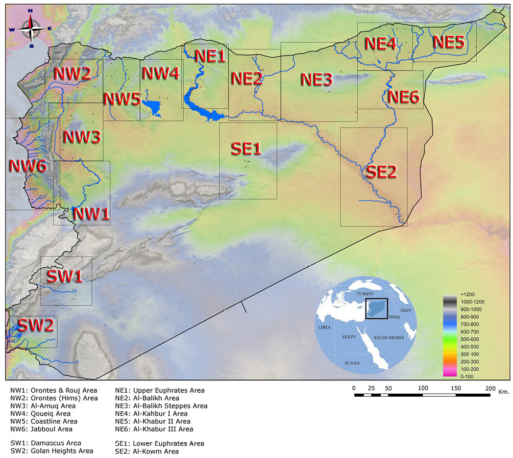
Map 1. Settlements Areas Index map (Author edition).
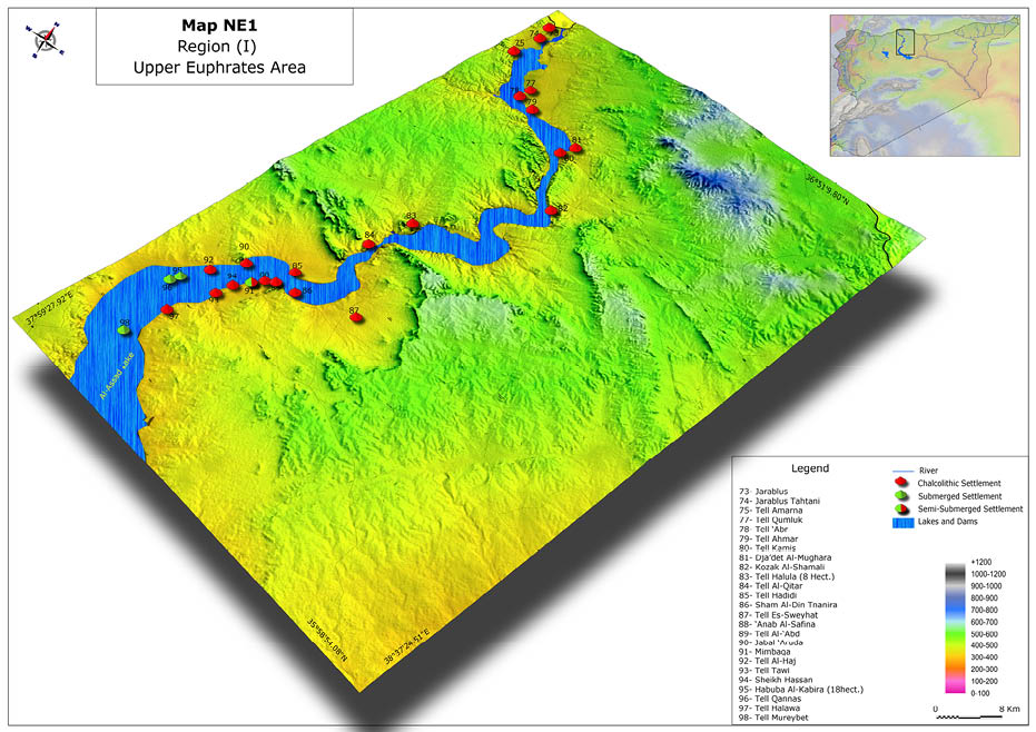
Map 2. Chalcolithic settlements localization in Syrian Upper Euphrates Area (Author edition).
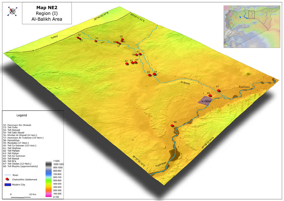
Map 3. Chalcolithic settlements localization in Al-Balikh Area (Author edition).
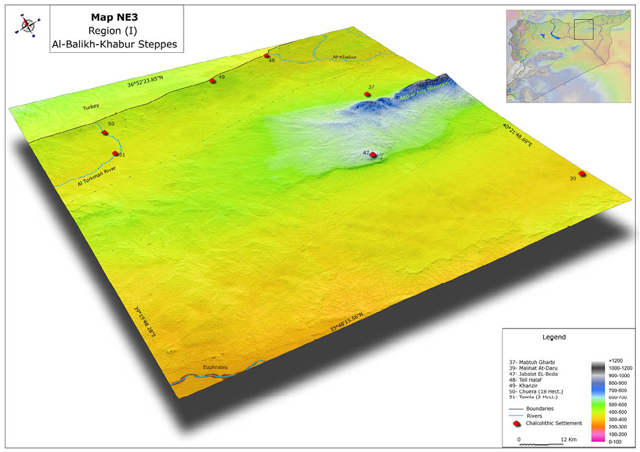
Map 4. Chalcolithic settlements localization in Al-Balikh/Al-Khabur Steppes (Author edition).
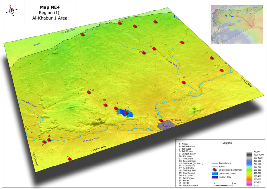
Map 5. Chalcolithic settlements localization in Al-Khabur Area I (Author edition).
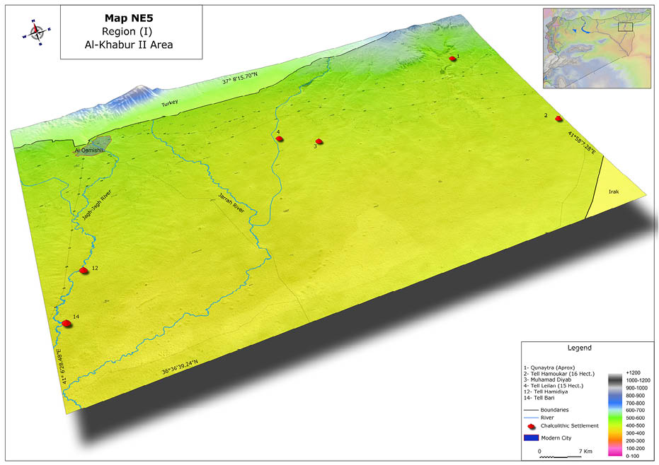
Map 6. Chalcolithic settlements localization in Al-Khabur Area II (Author edition).
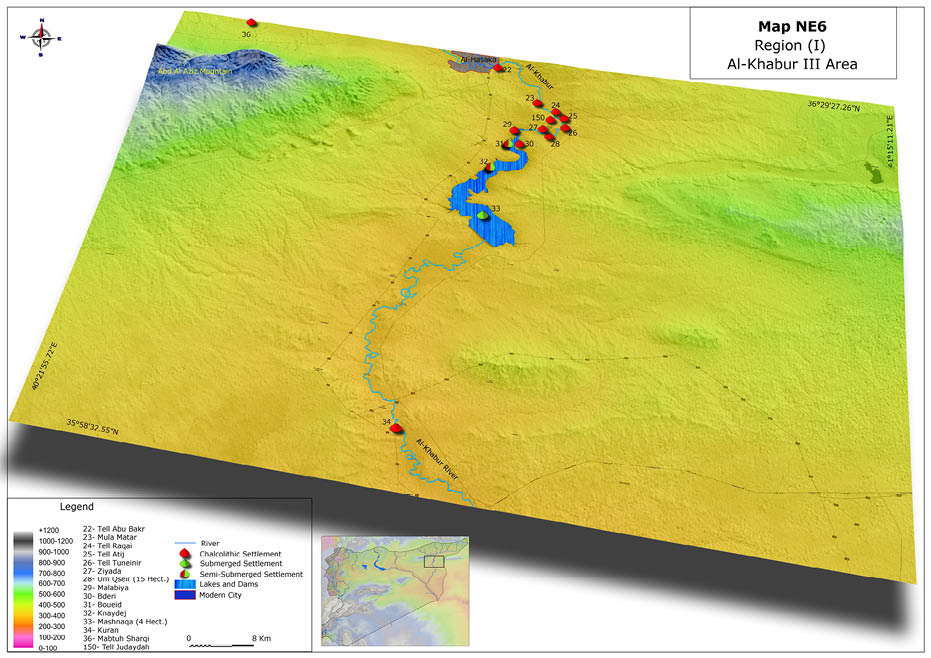
Map 7. Chalcolithic settlements localization in Al-Khabur Area III (Author edition).
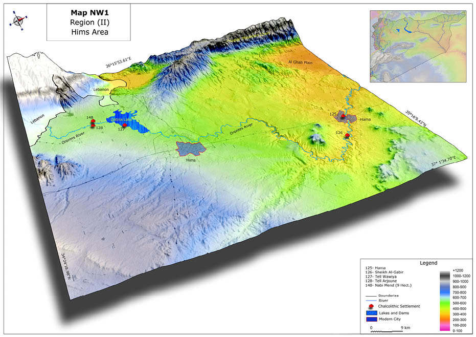
Map 8. Chalcolithic settlements localization in Hims Area (Author edition).
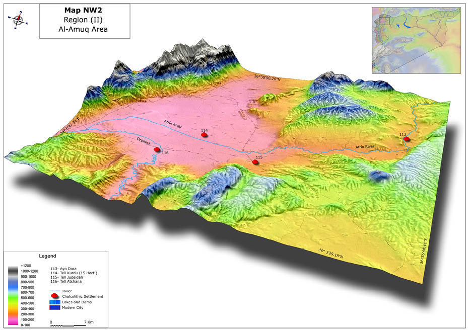
Map 9. Chalcolithic settlements localization in Al-Amuq Area (Author edition).
Map 10. Chalcolithic settlements localization in Orontes & Rouj Areas (Author edition).
Map 11. Chalcolithic settlements localization in Jabboul Area (Author edition).
Map 12. Chalcolithic settlements localization in Qoueiq Area (Author edition).
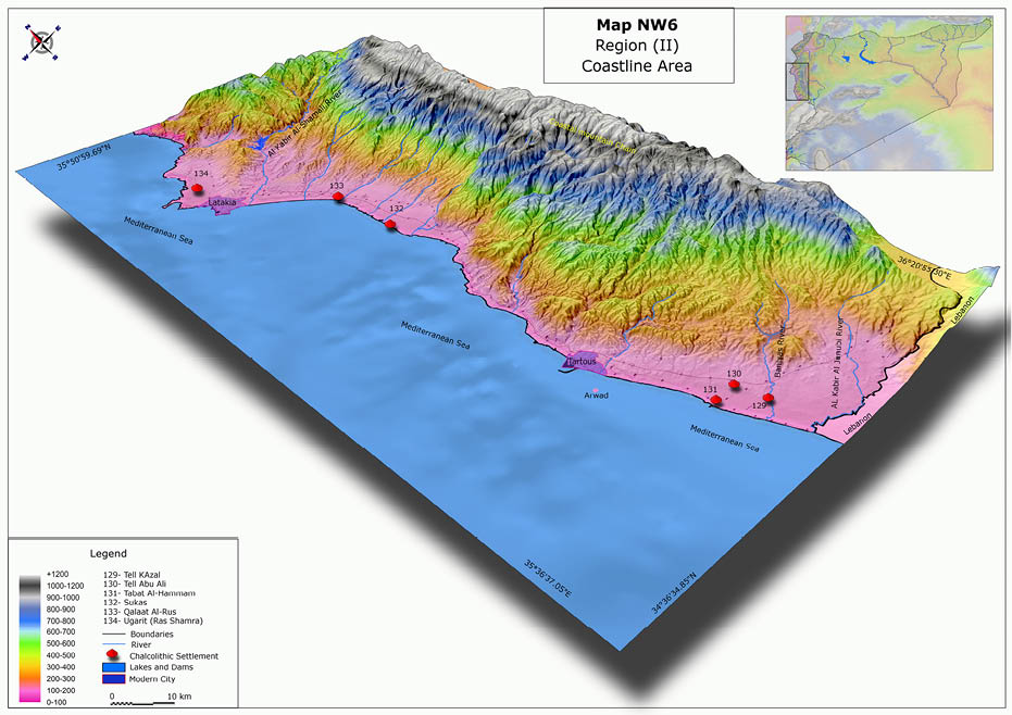
Map 13. Chalcolithic settlements localization in Coastline Area (Author edition).
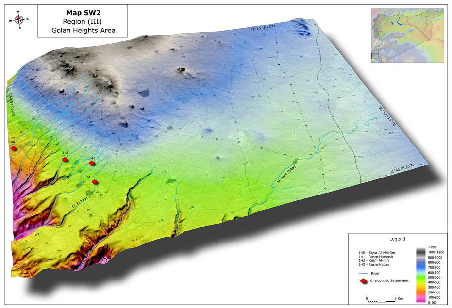
Map 14. Chalcolithic settlements localization in Heights Golan Area (Author edition).
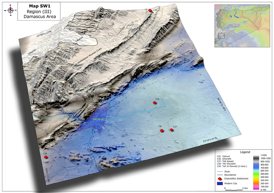
Map 15. Chalcolithic settlements localization in Damascus Area (Author edition).
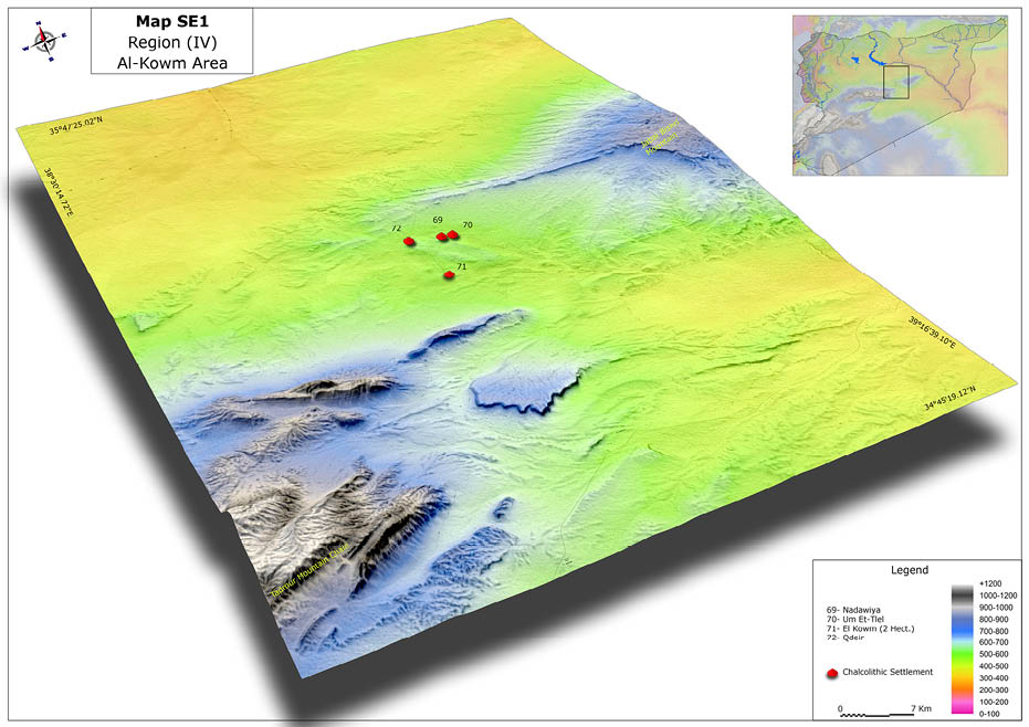
Map 16. Chalcolithic settlements localization in Al-Kowm Area (Author edition).
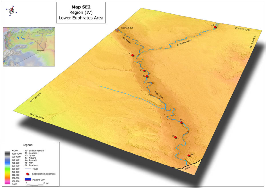
Map 17. Chalcolithic settlements localization in Syrian Lower Euphrates Area (Author edition).
Table 1. Chalcolithic settlements in the Syrian Upper Euphrates
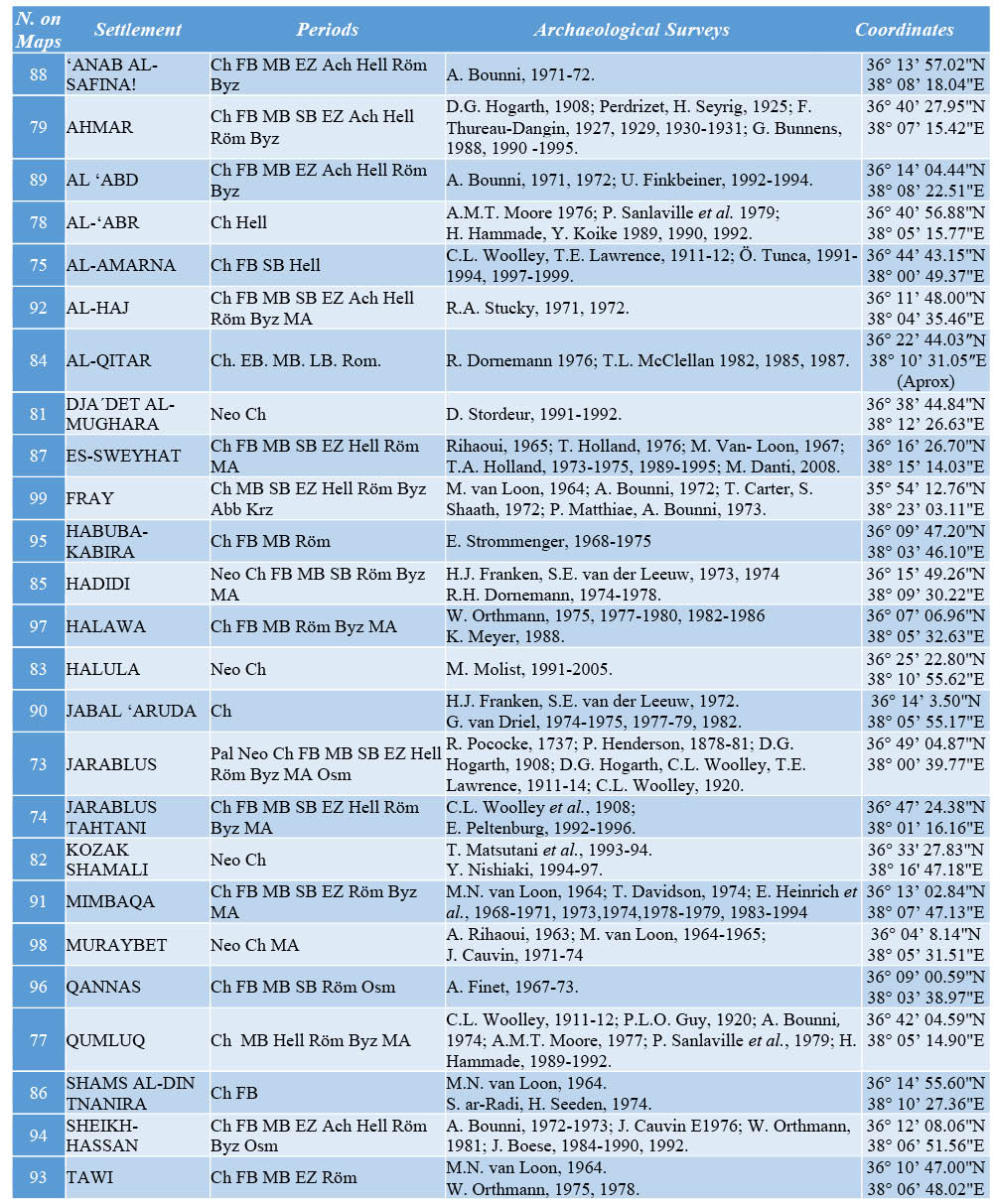
Table 2. Chalcolithic settlements in Al-Balikh area and Al-Balikh/Al-Khabur Steppes
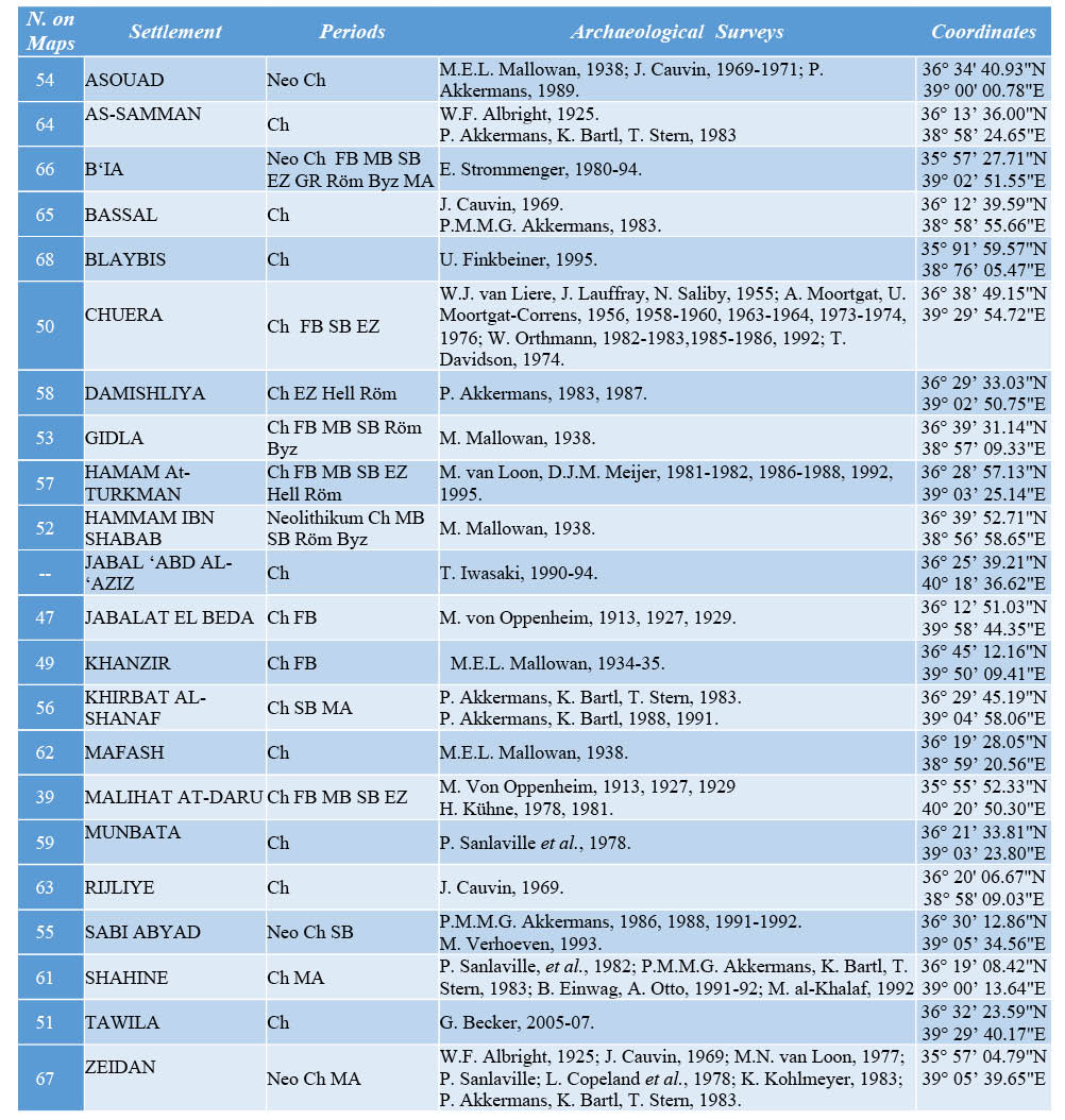
Table 3. Chalcolithic settlements in Al-Khabur Area
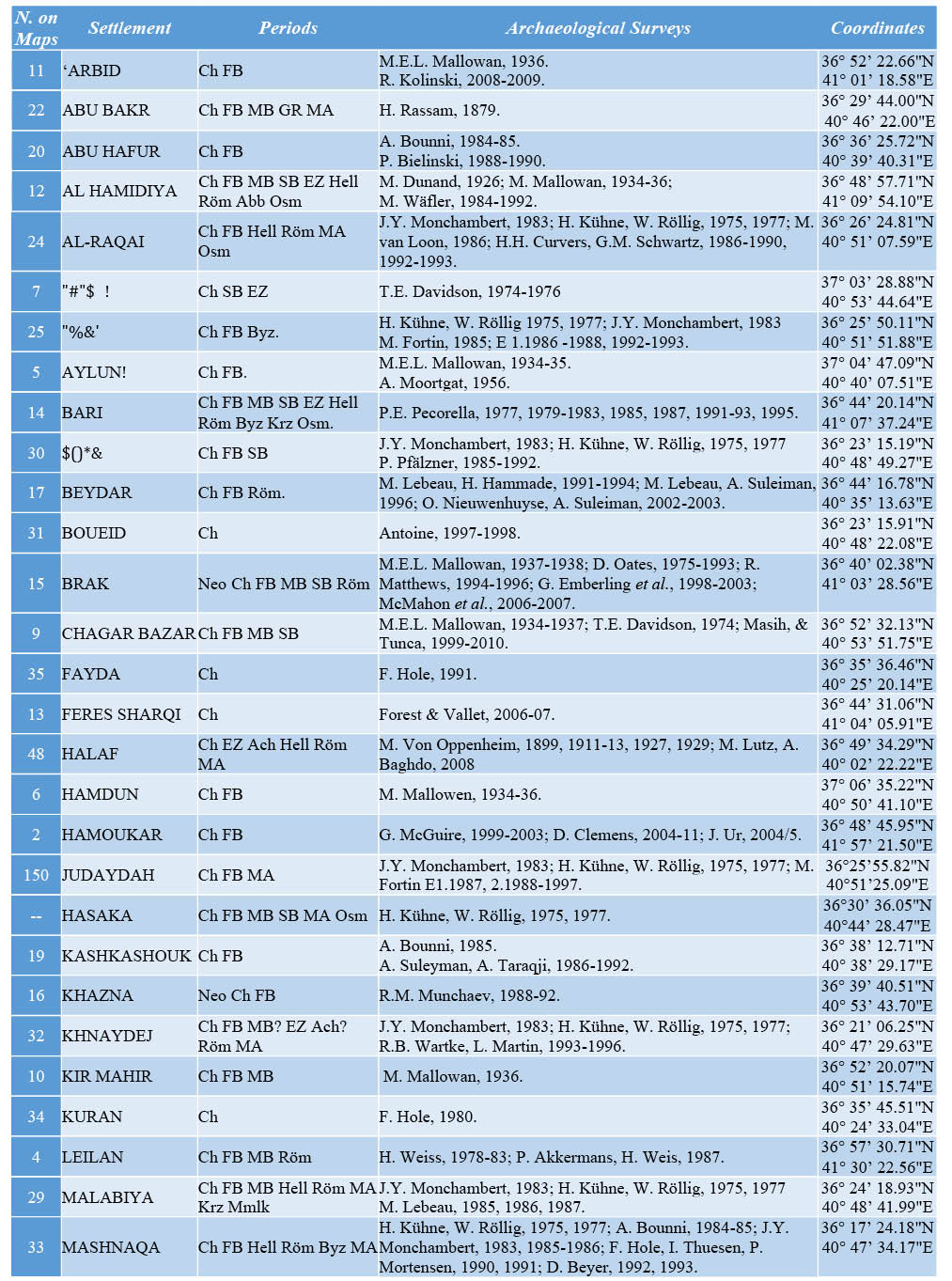
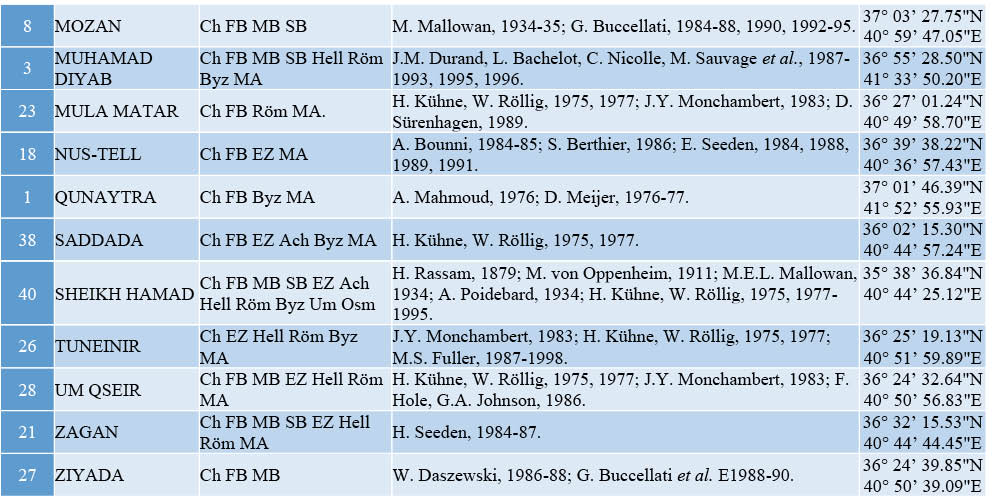
Table 4. Chalcolithic settlements in Orontes Area
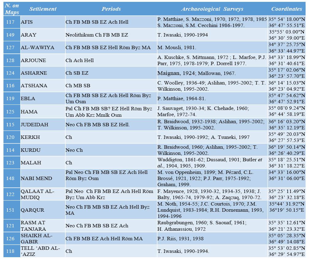
Table 5. Chalcolithic settlements in Jabboul Area
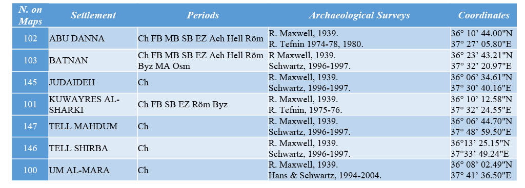
Table 6. Chalcolithic settlements in Qoueiq Area
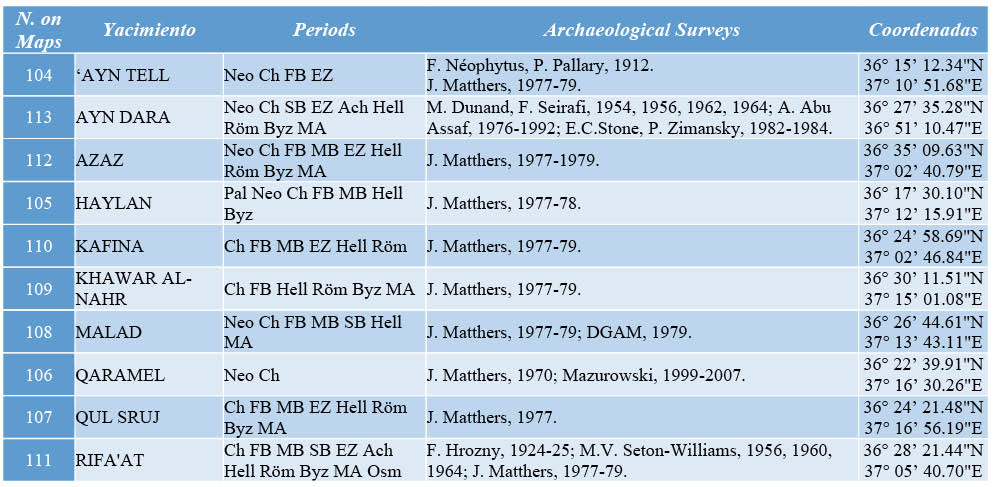
Table 7. Chalcolithic settlements in Littoral Area
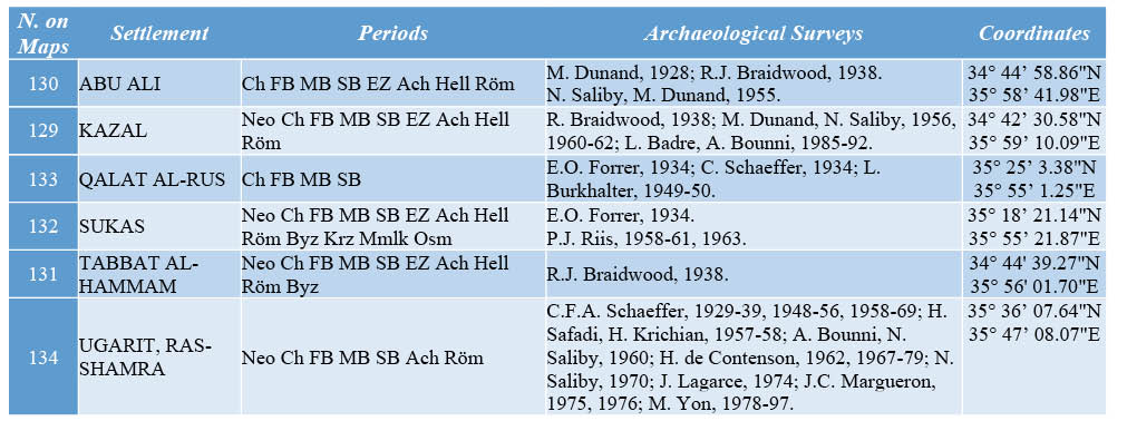
Table 8. Chalcolithic settlements in Damascus and Golan Heights Areas
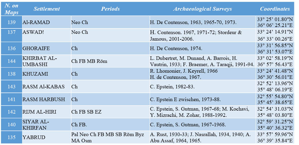
Table 9 Chalcolithic settlements in Al-Kowm and Syrian Lower Euphrates areas
REFERENCES
ABD EL-SALAM, A. (1989): Geographic regions of Syria, Al Itihad, Damascus.
AL-MAQDISSI, M. (2003): “Notes d´archéologie levantine I., prospection de la région autour de Tell Kazal”, Annales Archéologiques Arabes Syriennes 45/46, pp. 39- 48.
ALGAZE, G. (1986): “Habuba on the Tigris: Archaic Nineveh Reconsidered”, Journal of Near Eastern Studies 45 (2), pp. 125-37.
ALGAZE, G. (2013): “The end of prehistory and the Uruk period”, The Sumerian World (Harriet Crawford ed.), pp. 68-94.
AKKERMANS, P.M.M.G. (1987): “Excavations at Tell Damishliya, a Neolithic settlement in the Balikh Valley, Northern Syria”, Arabic ed., translated by Sh. Shawqi, Annales Archéologiques Arabes Syriennes 36/37, pp. 211-218.
AKKERMANS, P.M.M.G. (1989): “The Neolithic of the Balikh Valley, Northern Syria: A First Assessment”, Paléorient 15 (1), pp. 122-134.
AKKERMANS, P.M.M.G. (2013a): “Northern Syria in the Late Neolithic, ca. 6800–5300 BC”, Archéologie et Histoire de la Syrie, Vol I:, La Syrie de l’époque néolithique à l’âge du fer (O. Winfried, P. Matthiae & M. Al-Maqdissi ed.), Otto Harrassowitz, pp. 17-32.
AKKERMANS, P.M.M.G. (2013b): “Living Space, Temporality and Community Segmentation: Interpreting Late Neolithic Settlement in Northern Syria”, Interpreting the Late Neolithic of Upper Mesopotamia In O. Nieuwenhuyse, (R. Bernbeck, P.M.M.G. Akkermans & J. Rogash ed.), Turnhout, Brepols, pp. 63-75.
AKKERMANS, P.M.M.G. & SCHWARTZ G. (2004): “The Archaeology of Syria. From Complex Hunter-Gatherers to Early Urban Societies (ca. 16 000-300 B.C.)”, Syria 81 (1), pp. 263-66.
ANSCHUETZ, K.K.F., WILSHUSEN R.H. & SCHEICK C.L. (2001): “An Archeology of Landscapes: Perspectives and Directions”, Journal of Archeological Research 9 (2), pp. 157-211.
ARDELEAN, C.F. (2004): “Factores causales del patrón de asentamiento en arqueología”, Boletín de arqueología Americana 40, pp. 99-138.
BALBO, A., BOIX, J., IBÁÑEZ, J.J., IRIARTE, E., TERRADAS-BATLLE, X., HAÏDAR-BOUSTANI M. & AL-MAQDISSI, M. (2009): “La ocupación prehistórica al oeste de Homs, Campañas de 2008”, Informes y trabajos, excavaciones en el exterior 2008-2009, Vol. 9. Ministerio de Educación, Cultura y Deporte, Madrid, pp. 209-227.
BANNING, E.B. (2007): “Time and tradition in the transition from late Neolithic to chalcolithic: Summary and conclusions”, Paléorient 33 (1), pp. 137-42.
BARREYRA, D. (2001): “Uso de los recursos naturales y construcción de la etnicidad. La ciudad-estado de Mari y la región del medio Éufrates y el rio Khabur”, Estudios de Asia y África XXXVI (2), pp. 235-250.
BECKER, J. (2006): “Excavations at Tell Tawila (NE-Syria) from Halaf to Ubaid, Informe preliminar de la primera temporada de 2005”. (Traduced by David Tucker) Seminar for Oriental Archaeology and Art History, Institut für Altertumswissenschaften Martin-Luther-University Halle-Wittenberg.
BECKER, J. & HELMS T. (2013): “A Halafian Ritual Deposit from Tell Tawila”, Neo-Lithics 1/13, pp. 24-36.
BESANÇON, J. & GEYER, B. (1995): “La cuvette du Ruğ (Syrie du Nord). Les conditions naturelles et les étapes de la mise en valeur”, Syria 72 (3/4), pp. 307-355.
BESANÇON, J., COPELAND, L., HOURS, F., MUHESEN, S. & SANLAVILLE, P. (1982): “Le Paléolithique d’El Kowm, rapport préliminaire”, Paléorient 7 (1), pp. 33-35.
BOËDA, E., GENESTE, J. M. & GRIGGO, C. (1999): “A Levallois point embedded in the vertebra of (Equus africanus): hafting, projectiles and Mousterian hunting weapons”, Antiquity 73, pp. 394-402.
BOUNNI, A., SALIBI N., TWER Q. & ZAQZUQ A. (1974): “Preliminary report on the archaeological excavations at Tell Al-Abd and Anab al Safina (Euphrates), 1971 - 1972”, (Arabic ed.), Annales Archéologiques Arabes Syriennes XXIV (1-2), pp. 53-63.
BRAEMER, F. (1984) “Prospections archéologiques dans le Ḥawrān (Syrie)”, Syria LXI, pp. 219-250.
BRAEMER, F., ECHALLIER, J. & TARAQJI, A. (1993) : “Khirbet el Umbashi (Syrie) Rapport préliminaire sur les campagnes 1991 et 1992”, Syria LXX, pp. 415-429.
BRESSY, C., POUPEAU, G. & YENER, K.A. (2005): “Cultural interactions during the Ubaid and Halaf periods: Tell Kurdu (Amuq Valley, Turkey) obsidian sourcing”, Journal of Archaeological Science 32, pp. 1560 -1565.
CARTER, R. A. & GRAHAM, P. H. (2010): “Deconstructing the Ubaid”, Beyond the Ubaid: Transformation and Integration in the Late Prehistoric Societies of the Middle East. Papers from ‘The Ubaid expansion? Cultural Meaning, Identity and the Lead-up to Urbanism’. In International Workshop Held at Grey College (Robert A. Carter & Graham Philip ed.), University of Durham, The Oriental Institute of the University of Chicago: Chicago, pp. 1-22.
CASANA, J. & WILKINSON, J. M. (2005): “Settlement and landscapes in the Amuq Region”, The Amuq Valley region Projects. Vol. 1 Survey in the plain of Antioch and Orontes Delta, Turkey, 1995-2002, (K. A. Yener ed.), Oriental institute publications 131, the Oriental Institute of the University of Chicago, pp. 25-65.
CHILDE, G.V. (1996): Los Orígenes de la Civilización, Fondo de cultura económica, México, reimpresión 1996.
CAUVIN, M.C., KELLER, J. & PERNIKA, E. (1997): “Obsidian from Anatolian sources in the Neolithic of the Middle Euphrates region (Syria)”, Paléorient 23 (1), pp. 113-122.
CÓRDOBA, J.M. (1988): “Prospección en el Valle del Rio Balikh, (Siria) informe provisional”, Aula-Orientalis 62 (2), pp. 149-188.
CHRISTIDOU, R., COQUEUGNIOT, E. & GOURICHON, L. (2009): “Neolithic figurines manufactured from phalanges of equids from Dja’de el Mughara, Syria”, Journal of Field Archaeology 34(3), pp. 319-335.
COPELAND, L. (1979): “Observations on the prehistory of the Balikh valley, Syria, during the 7th to 4th Millennia B.C”, Paléorient 5, pp. 251-275.
COPELAND, L. (1981): “Flint industries of the Nahr Qoueiq Valley”. The river Qoueiq, Northern Syria, and its catchment, (J. Matthers éd.), BARIS 98, pp. 81-130.
CRUELLS, W. (2009): “Nouvelles données sur les origines et le développement de la céramique Halaf en Syrie”, Méthodes d’approche des premières productions céramiques : étude de cas dans les Balkans et au Levant, (Laurence Astruc, Alain Gaulon et Laure Salanova ed.), pp. 93-103.
CRUELLS, W. & MOLIST, M. (2006): “Chagar Bazar au sein de la préhistoire de Bassin du Khabour”, Chagar Bazar (Syrie) I les sondages préhistoriques 1999-2001, (O. Tunca & Abd Al Masih Baghdo ed.), Peeters Louvain, Paris, pp. 143-155.
DE CONTENSON, H. (1970): “Rapport préliminaire sur le sondage ouvert en 1962 sur l’acropole de Ras Shamra. Campagnes 1962-1968”, Annales Archéologiques Arabes Syriennes 20, pp. 13-24.
DE CONTENSON, H. (1975): “Les fouilles de Ghoraifé en 1974”, Annales Archéologiques Arabes Syriennes XXV, pp.17-32.
DE CONTENSON, H. (1982): “Les Phases préhistoriques de Ras Shamra et de l’Amuq”. Damas, Paléorient 8, pp. 95-98.
DE CONTENSON, H. (1985): “La région de Damas dans le Néolithique”, Annales Archéologiques Arabes Syriennes 35, pp. 9-29.
DE CONTENSON, H. (1996): “Les premiers villageois de Mésopotamie. Du village à la ville”, Syria 73 (1), pp. 215-218.
DORRELL, P.G. (1981): “The Qoueiq Valley: the physical background”, (Matthers ed.), The River Qoueiq, Northern Syria, and its catchment, BARIS 98, pp. 75-80.
GAULON, A. (2010): “Expansion, stratégies d’implantation et hiérarchisation des communautés halafiennes en Mésopotamie du nord aux VIe et Ve millénaires av. J.-C.: contraintes environnementales et choix sociaux-économiques”, Regards croisés sur l’étude archéologique des paysages anciens. Nouvelles recherches dans le Bassin méditerranéen, en Asie centrale et au Proche et au Moyen-Orient, (Jean Pouilloux ed.) Maison de l’Orient et de la Méditerranée, Lyon, pp.65-78
GERRITSEN, F., DE GIORGI, A., EGER, A., ÖZBAL, R. & VORDERSTRASSE, T. (2008): “Settlement and Landscape Transformations in the Amuq Valley, Hatay. A Long-Term Perspective”, Anatolica, 34, pp. 241-314.
GEYER, B., ROUSSET, M., AL-DBIYAT, M., AWAD, N., BARGUE, O., BESANSCON, J., CALVET, Y., GATIER, P.L. & JAUBERT, R. (2005): “Les marges arides de la syrie du Nord : premiere synthese d’une prospection geoacheologique”, Annales Archéologiques Arabes Syriennes 47/48, pp. 17-34.
GEYER, B. & BESANÇON, J. (1996): “Environnement et occupation du sol dans la vallée de l’Euphrate syrien durant le Néolithique et le Chalcolithique”, Paléorient 22 (2), pp. 5-15.
GEYER, B. & BESANÇON, J. (2002): “Environmental and land-use evolution in the Syrian Euphrates valley during the Neolithic and chalcolithic periods”, Documents d’archéologie Syrienne Vol. I, The Syrian Jezira Cultural Heritage and interrelations, (M. Al Maqdisi, A. Maamoun, A. Al-Azm and M. D. Al-Khoury ed.), Proceeding of the international Conference held in Deir ez-Zor, April 22-25 1996. DGAM, Damascus, pp. 61-68.
GEYER, B., BESANÇON, J. & ROUSSET, M.O. (2006): “Les peuplements anciens”, Conquête de la steppe 2; Les marges arides du Croissant fertile, peuplements, exploitation et contrôle des ressources en Syrie du Nord, (R. Jaubert and B. Geyer ed.), Maison de l’Orient et de la Méditerranée, Lyon, (43), pp. 55-70.
GEYER, B. & MONCHAMBERT, J.Y. (1983): “Expedition in the lower Euphrates Valley”. (Arabic ed. Translated by Toueir Q), Annales Archéologiques Arabes Syriennes 34, pp. 229-23.
HASSAN, M.A. (1995): Syria, geography and politics, (Arabic ed.), Ministry of Culture, Damascus.
HOLE, F. (2009): “Drivers of Unsustainable Land Use in the Semi-Arid Khabur River Basin, Syria”, Geographical Research 47(1), pp.4–14
IWASAKI, T. & TSUNEKI, A. (1999): “Archaeological investigations of the Rouj Basin, Idlib”, Annales Archéologiques Arabes Syriennes 43, pp. 83-92.
JAUBERT, R. & GEYER, B. (2006): Les marges arides du Croissant fertile, peuplements, exploitation et contrôle des ressources en Syrie du Nord. Maison de l’Orient et de la Méditerranée, Lyon.
KAFAFI, Z. (2010): “The Chalcolithic period in the Golan Heights: a regional or local culture”, Paléorient 36 (1), pp. 141-157.
KARSGAARD, P. (2010): “The Halaf-Ubaid Transition: a transformation without a center”, Beyond the Ubaid: Transformation and Integration in the Late Prehistoric Societies of the Middle East, (Robert A. Carter & Graham Philip ed.), Papers from ‘The Ubaid expansion? Cultural Meaning, Identity and the Lead-up to Urbanism. In International Workshop Held at Grey College, University of Durham. The Oriental Institute of the University of Chicago, Chicago, pp. 51-69.
KHADOUR, M., BALLOUT, S. & AL-NASAN, M. (2013): Geography of the Arab World, Ministry of Education, Damascus.
LAWRENCE, D. (2012): Early Urbanism in the Northern Fertile Crescent: A Comparison of Regional Settlement Trajectories and Millennial Landscape Change. Ph.D. Durham University.
LE MIÈRE, M. & NIEUWENHUYSE, O. (2000) : “L’occupation Proto-Hassuna du Haut-Khabur occidental d’après la céramique”, (Lyonnet ed.), Prospection archéologique du Haut-Khabour occidental (Syrie du nord-est) Vol. I, IFAPO, Beyrouth, pp. 127-150.
LE TENSORER, J.M., THOMAS, H., DOROTA, W. (2003): “Le Paléolithique Ancien et Moyen d’hummal (El Kowm, Syrie Centrale)”, SWIATOWIT Tom V (XLVI) FASC. B, pp. 45-52.
LEE, C. E., & ROHLING, J., BERNARD, W. & JOHANA, H. (2008): “Warfare in late Neolithic Pisidia Southwestern Turkey, Climate induced social unrest in the late 7th Millennium calBC”, Documenta Praehistorica XXXV, pp. 65-92.
LEVÊQUE, P. (1991): Las primeras civilizaciones, De los despotismos orientales a la ciudad griega, Akal, Madrid.
LIUDMILA, A. (2008): “Regional models of metal production in western Asia in the chalcolithic, early and middle Bronze Ages”, Trabajos De Prehistoria 65 (1), pp. 73-91.
LYONNET, B. (2000): Prospection archéologique Haut-Khabur occidental (Syrie du n.e.) volume I. Institut français d’archéologie du Proche-Orient Beyrouth –damas-amman. Beyrouth.
MALLOWAN, M.E.L. (1967): Ancient history, the development of cities from Al Ubaid to the end, Uruk 5 Vol. I, University of Cambridge, London.
MANNING, S.W. (2007): “Preface. Beyond Dates to Chronology: Rethinking the Neolithic-Chalcolithic Levant”, Paléorient 33(1), pp. 5-10.
MANZANILLA, L. (1988): “El surgimiento de la sociedad urbana y la formación del estado: consideraciones”, Estudios sobre la revolución neolítica y la revolución urbana. Coloquio en homenaje a V. Gordon Childe, Universidad Nacional Autónoma de México, México, pp.293-308.
MATTHERS, J. (1981): The River Qoueiq, Northern Syria, and its catchment, Studies Arising from the Tell Rifa’at Survey 1977-79, BARis International Series 98, Oxford.
MAZZONI, S. (1999): “Tell Afis and its region in the late chalcolithic period”, Annales Archéologiques Arabes Syriennes XLIII, pp. 97-118.
McCORMICK, A. R. & NISSEN, H. J. (1972): The Uruk Countryside, The natural setting of urban societies, University of Chicago Press, Chicago.
McCORRISTON, J. (1992): “The Halaf environment and human activities in the Khabur drainage, Syria”, Journal of field Archeology 19 (3), pp. 315-333.
MENZE, B.H., UR, J.A. & SHERRATT, A.G. (2006): “Detection of Ancient Settlement Mounds: Archaeological Survey Based on the SRTM Terrain Model”. Photogrammetric Engineering & Remote Sensing Vol. 72 (3), pp. 321-327.
MIYAKE, M. &, TSUNEKI, A. (1996): “The Earliest Pottery Sequence of the Levant: New Data from Tell El-Kerkh 2, Northern Syria”, Paléorient 22 (1), pp. 109-123.
MILLER, F. N. (1997): “The Macro-botanical evidence for vegetation in the Near East, C. 18 000/16 000 B.C to 4 000 B.C”, Paléorient 23 (2), pp. 197-207.
MONTERO FENOLLÓS J. L. (2006): B. Geyer Et J.Y. Monchambert (Dir.) Avec J. Besançon Et É. Coqueugniot. 2003. La basse vallée de l’Euphrate syrien du Néolithique à l’avènement de l’Islam: géographie, archéologie et histoire, Beyrouth: Institut Français du Proche-Orient, Recensions, pp. 195-197.
MOLIST, M. M. (1984): “Investigaciones prehistóricas en la región del Kowm, Siria central”, Pyrenae 19/20, pp. 235-249.
MOLIST, M. M. (1996): “Tell Halula: mission espagnole”, Institut français d’études arabes de Damas Syrian-European Archaeology Exhibition, Damascus National Museum, May 30th-July 11th 1996, Working Together, Damascus, pp. 41-46
MOLIST, M., ANFRUNS, J., BOFILL, M., BORRELL, F., BUXÓ, R., CLOP, X., WALTER, C, FAURA, J. M., FERRER, A., GÓMEZ, A., GUERRERO, E., SAÑA, M., TORNERO, C., VICENTE, O., BUXÓ R. (2013): “Tell Halula (Euphrates valley, Syria): New data from the late Neolithic settlement”, Interpreting the Late Neolithic of Upper Mesopotamia, (O. Nieuwenhuyse, R. Bernbeck, P.M.M.G. Akkermans and J. Rogash ), Turnhout: Brepols, pp. 443-453.
MOLIST, M., ANFRUNS, J., BOSCH, J., BORRELL, F. BUXO, R., CLOP, X., CRUELLS, W., FAURA, J.M., FERRER, A., GOMEZ, A., GONZALEZ, M., GUERRERO, E., SAÑA, M., TORNERO, C. & VICENTE, O. (2007): “Sixteen Years of Archaeological Investigations in the Euphrates Valley and the Djezireh: Tell Halula, Tell Amarna, and Chagar Bazar”, Neo-Lithics 1/07, pp. 9-13.
MUHESEN, S. (1994): Bilad Al Sham in prehistory: The first farmers. Dar Al-Abjadiya publisher, (Arabic ed.), Damascus.
MUHESEN, S. (1997): “Prehistoric Ages in southern Syria (Al Swayda and Daraa provinces)”, Annales Archéologiques Arabes Syriennes 41, Arabic ed., pp. 43-60.
MUHESEN, S. (1999): “Prehistory of Aleppo region”, Annales Archéologiques Arabes Syriennes 43, pp. 243-244.
NASRALLAH, R.P.J. (1956): “Le Ghassoulien de Der’a Al Hauran”, Bulletin de la Société préhistorique française LIII (11-12), pp. 735-746.
NIEUWENHUYSE, O. (1999): “Tell Baghouz reconsidered: a collection of ¨Classic¨ Samarra shreds from the Louvre”, Syria 76, pp. 1-18.
NIEUWENHUYSE, O. (2010): “A household affair? Pottery production in the burnt village at late Neolithic Tell Sabi Abyad”, Development of pre-State communities in the ancient Near-east, (Diane Bolger & Louise Maguire ed.), Oxbow Books, pp. 97-105.
ÖZBAL, R. (2010a): “The emergence of Ubaid styles at tell Kurdu: a local perspective”, Beyond the Ubaid: Transformation and Integration in the Late Prehistoric Societies of the Middle East, (Robert A. Carter & Graham Philip ed.), Papers from ‘The Ubaid expansion? Cultural Meaning, Identity and the Lead-up to Urbanism’, In International Workshop Held at Grey College, University of Durham, The Oriental Institute of the Universit of Chicago, Chicago, pp. 293-310.
ÖZBAL, R. (2010b): “A comparative look at halaf and ubaid period social complexity and the tell kurdu case”, Tuba-Ar-Turkish Academy Of Sciences Journal Of Archaeology 13, pp. 39-59.
ÖZBAL, R. (2011): “The Chalcolithic of Southeast Anatolia”, The Oxford Handbook of Ancient Anatolia 10,000-323 BC, Sharon Steadman and Gregory McMahon, Oxford University Press, Oxford, pp. 174-204.
PAMIR, H. (2005): “The Orontes delta survey”, The Amuq Valley region Projects. Vol. 1 Survey in the plain of Antioch and Orontes Delta, Turkey, 1995-2002, (K. A. Yener ed.) Oriental institute publications, 131, the Oriental Institute of the University of Chicago, pp. 67-98.
PARDO, M.P. (2001): “El posible intercambio comercial de las materias primas en el neolítico próximo oriental”, II Congreso Español De Antiguo Oriente Próximo. El Mediterráneo en la Antigüedad: Oriente y Occidente, CEPO, CSIC, Universidad de Cádiz.
PARKER, B.J. (2010): “Networks of interregional interaction during Meopotamia´s Ubaid period”. In Robert A. Carter & Graham Philip ed.; Beyond the Ubaid: Transformation and Integration in the Late Prehistoric Societies of the Middle East. Papers from ‘The Ubaid expansion? Cultural Meaning, Identity and the Lead-up to Urbanism’. In International Workshop Held at Grey College, University of Durham, pp. 347-368.
PICON, M. & LE MIÈRE, M. (1987): “Productions locales et circulation des céramiques au VIe millénaire, au Proche-Orient”, Paléorient 13 (2), pp. 133-147.
REDMAN, C. (1990): Los orígenes de la civilización desde los primeros agricultores hasta la sociedad urbana en el Próximo Oriente, Editorial Crítica, Barcelona.
ROUAULT, O. (1998): “Villes, villages, campagnes et steppe dans la région de Terqa: données nouvelles”, Espace naturel, espace habité en Syrie du Nord (10e-2e millénaires av. J.-C.) / Natural Space, inhabited Space in Northern Syria (10th-2nd millennium B.C.), Actes du colloque tenu à l’Université Laval (Québec) du 5 au 7 mai 1997. Lyon, Maison de l’Orient et de la Méditerranée Jean Pouilloux, 1998, (Travaux de la Maison de l’Orient méditerranéen), pp. 191-198.
ROUX, G. (2002): Mesopotamia, historia política, económica y cultural, Akal, Madrid.
RUSSELL, A. (2010): Retracing the steppes: a zooarchaeological analysis of changing subsistence patterns in the late Neolithic at Tell Sabi Abyad, northern Syria, c. 6900 to 5900 BC”. Ph.D. Doctoral, Faculty of Archaeology, Leiden University.
SANLAVILLE, P., MUHESEN, M., COPELAND, L. & BESANÇON, J. (1994): “Prospection géomorphologique et préhistorique dans la région de Tartous (Syrie)”, Paléorient 20 (1), pp. 5-19.
SANMARTÍN, J.A. & SERRANO, J.S. (1998): Historia antigua del Próximo Oriente: Mesopotamia y Egipto, Akkal, Madrid
SÁNCHEZ, J. E. (1991): Espacio, Economía y Sociedad, Siglo XXI, Barcelona.
VALENTÍN, I. (1982): “El espacio geográfico y las demarcaciones territoriales en prehistoria”, Norba 3, pp. 139-144.
SCHWARTZ, G.M., HANS H. C., FOKKE, A. & GERRITSEN, J.A. (2000): “Excavation and Survey in the Jabbul Plain, Western Syria: The Umm el-Mara Project 1996-1997”, American Journal of Archaeology 104 (3), pp. 419-462
SHERRATT, A. (2005): “The Obsidian Trade in the Near East, 14,000 to 6500 BC”. ArchAtlas, Version 4.1, available in: http://www.archatlas.org/ObsidianRoutes/ObsidianRoutes.php
STAUBWASSER, M. & WEISS, H. (2006): “Holocene climate and cultural evolution in the late prehistoric, early historic West Asia”, Quaternary Research 66 (3), pp. 372-387.
STEIN, J. (1999): “Material Culture and Social Identity: the Evidence for a 4th Millennium BC Mesopotamian Uruk Colony at Hacinebi, Turkey”, Paléorient 25 (1), pp. 11-22.
STEIN, J. (2012): “the development of indigenous social complexity in late chalcolithic upper Mesopotamia in the 5th-4th millennia BC. An initial assessment”, ORIGINI XXXIV, pp. 125-151.
STEIN, J., HOLLANDER, . & SCHWARTZ, M. (1999): “Reconstructing Mesopotamian Exchange Networks in the 4th Millennium BC: Geochemical and Archaeological Analyses of Bitumen Artifacts from Hacinebi Tepe, Turkey”, Paléorient 25 (1), pp. 67-82.
STORDEUR, D. (1989): “El Kowm 2 Caracol et Le PPNB”, Paléorient 15 (1), pp. 102-110.
STORDEUR, D., ABBÈS, F. (2007): “From the First Villages to the First Cities. A Permanent Exhibition at the National Museum of Damascus”, Neo-lithics 1/07, pp. 43-47.
STUCKY, R. (1975): “Tell Al Haj, second season of excavations”, Annales Archéologiques Arabes Syriennes 25 (1-2), pp. 165-182.
SWEENEY, J.S. & WALTER, W. (1998): Preliminary definition of geophysical Regions for the Middle East and North Africa, Lawrence Livermore National Laboratory, California.
THUESEN, I. (1996): “Tell Mashnaqa”, La Syrie préhistorique: Exposition archéologique Syro-Européenne, (Muhesen Sultan ed.), l’Institut Français d’Etudes Arabes de Damas, Damas, pp. 47-54.
TOUEIR, Q. (1983): “Traveling settlements along the Euphrates”, (Arabic ed.), Annales Archeologiques Arabes Syriennes 33 (1), pp. 51-66.
TRENTIN, G.M. (2010): “The Ubaid in the Balikh Valley, Northern Syria: Balikh Periods IV–V”, Beyond the Ubaid: Transformation and Integration in the Late Prehistoric Societies of the Middle East, (Robert A. Carter and Graham Philip ed.), papers from ‘The Ubaid expansion? Cultural Meaning, Identity and the Lead-up to Urbanism’, In International Workshop Held at Grey College, University of Durham, pp. 329-338.
TSUNEKI, A., ARIMURA, M., MAEDA, O., TANNO, K. & ANEZAKI, T. (2005): “The Early PPNB in the North Levant: A new perspective from Tell Ain El-Kerkh, Northwest Syria”, Paléorient 32(1), pp. 47-71.
TSUNEKI, A. (1998): “Ending remarks”, Excavations at Tell Umm Qseir in Middle Khabur Valley, North Syria, (Tsuneki, A. y Miyake, Y. ed.) Institute of History and Anthropology, University of Tsukuba, pp. 203.
UR, A.J. (2004): Urbanism and society in the third millennium upper Khabur Basin. Vol.1, Chicago, Illinois.
UR, A.J. (2010a): “Tell Hamoukar, Vol. 1 Urbanism and cultural landscapes in northeastern Syria”. The Tell Hamoukar survey, 1999-2001, Oriental Institute Publications, 137, Chicago.
UR, A.J. (2010b): “Cycles of civilization in northern Mesopotamia, 4400-2000 BC.”, Journal of archeological research 18, pp. 387-431.
UR, A.J., PHILIP, K. & JOAN O. (2007): “Early Urban Development in the Near East”, Science 317(5842), pp. 1188.
VALDÉS, P.C. (1996): Los Materiales cerámicos de Tell Qara Quzaq: periodización de un yacimiento del III milenio en el norte de Siria, Ph.D. Departamento de Prehistoria, Historia Antigua y Arqueología, Universidad de Barcelona.
VALLET, R. (1996): “Habuba Kabira ou la naissance de l’urbanisme”, Paléorient 22 (2), pp. 45-76.
VAN-ZEIST, M.M.W. & BAKKER-HEERES, J.H.A. (1979): “Some economic and ecological aspects of the plant husbandry of Tell Aswad”, Paléorient 5 (1), pp. 161-169.
VIOLLET, P.L. (2004): L’hydraulique dans les civilisations anciennes 5000 ans d’histoire, Presses de l’Ecole Nationale des Ponts et Chaussées, Paris.
VV.AA. (1990): Gazetteer of the Syrian Arab Republic, Vol. I, Military Centre Studies, Syria Geographical Association and Surveying General Institution, Arabic ed. Dar Tlas, Damascus.
VV.AA. (1993): Geografía Universal Vol. 14, Instituto Gallach, Barcelona.
WEISS, H. (2003): “Work More? The 8.2 kaBP Abrupt Climate Change Event and the Origins of Irrigation Agriculture and Surplus Agro-Production in Mesopotamia”, American Geophysical Union, Fall Meeting Abstracts vol. 1, pp.1.
WEISS, H. & COURTY, M.A. (1993): “The genesis and collapse of the Akkadian empire: the accidental refraction of historical law”, Akkad the first world empire structure, ideology, traditions, (Mario Liverani ed.), Sargon, Padova, pp. 131-155.
WEISS, H. & YOUNG, JR.T.C. (1975): “The merchants of Susa, Godin v and plateau lowland relations in the late fourth Millennium BC”, Journal of Persian Studies 13, pp.1-17
WILKINSON, T.J. (1995): “The archaeological landscape of the Balikh Valley, Syria”, (William, M. ed.), The Oriental Institute 1995-1996, Annual Report, Oriental Institute, Chicago. pp. 18-21.
WILKINSON, T., MILLER, N., REICHEL, C. & WHITCOMB, D. (2004): On the margin of the Euphrates: settlement and land use at Tell Es-Sweyhat and in the upper Lake Assad area, Syria (Vol. 1). Oriental Institute of the University of Chicago Vol 124, Chicago.
WILKINSON, T.J., GRAHAM, P., BRADBURY, J., DUNFORD, R., DONOGHUE, D., GALIATSATOS, N., LAWRENCE, D., RICCI, A. & SMITH, S.L. (2014): “Contextualizing early urbanization: Settlement cores, early states and agro-pastoral strategies in the Fertile Crescent during the fourth and third millennia BC”. J World Prehist 27, pp.43-109.
WOSSINK, A. (2010): “Climate, history, and demography a case-study from the Balikh Valley, Syria”, Travaux de la Maison de l’Orient et de la Méditerranée, pp.181-192.
YENER, A.K. (2005): The Amuq Valley region Projects. Vol. 1 Survey in the plain of Antioch and Orontes Delta, Turkey, 1995-2002, Oriental institute publications, 131. The oriental institute of the University of Chicago, Chicago.
ZEDER, M.A. (1994): “After the revolution: Post-Neolithic subsistence in northern Mesopotamia”, American Anthropologist 96 (1), pp. 97-126.
ZEDER, M.A. (1998): “Environment, Economy, and Subsistence on the Threshold of Urban Emergence in Northern Mesopotamia”, Espace naturel, espace habité en Syrie du Nord (10e - 2e millénaires av. J.-C.), Actes du colloque tenu à l’Université Laval (Québec) du 5 au 7 mai 1997, Maison de l’Orient et de la Méditerranée Jean Pouilloux, Lyon, pp. 55-67.